


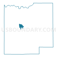
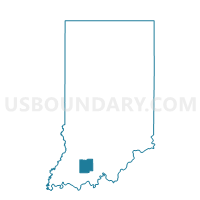
BAINBRIDGE 02E, Dubois County, Indiana
About
Outline

Summary
| Unique Area Identifier | 576966 |
| Name | BAINBRIDGE 02E |
| County | Dubois County |
| State | Indiana |
| Area (square miles) | 2.35 |
| Land Area (square miles) | 2.33 |
| Water Area (square miles) | 0.03 |
| % of Land Area | 98.76 |
| % of Water Area | 1.24 |
| Latitude of the Internal Point | 38.38106920 |
| Longtitude of the Internal Point | -86.93547190 |
Maps

Graphs
Select a template below for downloading or customizing gragh for BAINBRIDGE 02E, Dubois County, Indiana


Neighbors
Neighoring Voting District (by Name) Neighboring Voting District on the Map
- BAINBRIDGE 01, Dubois County, IN
- BAINBRIDGE 02W, Dubois County, IN
- BAINBRIDGE 03E, Dubois County, IN
- BAINBRIDGE 03W, Dubois County, IN
- BAINBRIDGE 04N, Dubois County, IN
- BAINBRIDGE 04S, Dubois County, IN
- BAINBRIDGE 05S, Dubois County, IN