


CASS 02, Dubois County, Indiana
About
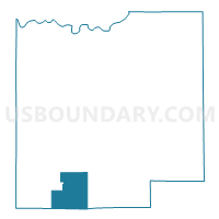
Outline

Summary
| Unique Area Identifier | 576955 |
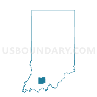
| Name | CASS 02 |
| County | Dubois County |
| State | Indiana |
| Area (square miles) | 14.12 |
| Land Area (square miles) | 14.04 |
| Water Area (square miles) | 0.08 |
| % of Land Area | 99.44 |
| % of Water Area | 0.56 |
| Latitude of the Internal Point | 38.23075580 |
| Longtitude of the Internal Point | -86.95799900 |
Maps

Graphs
Select a template below for downloading or customizing gragh for CASS 02, Dubois County, Indiana


Neighbors
Neighoring Voting District (by Name) Neighboring Voting District on the Map
- CARTER 01, Spencer County, IN
- CARTER 02, Spencer County, IN
- CASS 03, Dubois County, IN
- FERDINAND 03, Dubois County, IN
- PATOKA 05, Dubois County, IN
- PATOKA 06, Dubois County, IN
Top 10 Neighboring County Subdivision (by Population) Neighboring County Subdivision on the Map
- Patoka township, Dubois County, IN (7,527)
- Ferdinand township, Dubois County, IN (3,629)
- Carter township, Spencer County, IN (3,258)
- Cass township, Dubois County, IN (2,115)
Top 10 Neighboring Unified School District (by Population) Neighboring Unified School District on the Map
- North Spencer County School Corporation, IN (12,043)
- Southwest Dubois County School Corporation, IN (9,642)
- Southeast Dubois County School Corporation, IN (7,297)