


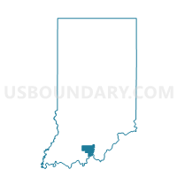
UNION 02, Crawford County, Indiana
About
Outline

Summary
| Unique Area Identifier | 576711 |
| Name | UNION 02 |
| County | Crawford County |
| State | Indiana |
| Area (square miles) | 15.20 |
| Land Area (square miles) | 15.20 |
| Water Area (square miles) | 0.00 |
| % of Land Area | 100.00 |
| % of Water Area | 0.00 |
| Latitude of the Internal Point | 38.22652490 |
| Longtitude of the Internal Point | -86.52110450 |
Maps


Graphs
Select a template below for downloading or customizing gragh for UNION 02, Crawford County, Indiana


Neighbors
Neighoring Voting District (by Name) Neighboring Voting District on the Map
- JOHNSON, Crawford County, IN
- OHIO 01, Crawford County, IN
- OIL, Perry County, IN
- UNION 01, Crawford County, IN
Top 10 Neighboring County Subdivision (by Population) Neighboring County Subdivision on the Map
- Oil township, Perry County, IN (2,546)
- Union township, Crawford County, IN (761)
- Ohio township, Crawford County, IN (742)
- Johnson township, Crawford County, IN (484)
Top 10 Neighboring Unified School District (by Population) Neighboring Unified School District on the Map
- Crawford County Community School Corporation, IN (11,086)
- Perry Central Community School Corporation, IN (7,358)