


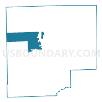
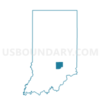
COLUMBUS 3400, Bartholomew County, Indiana
About
Outline

Summary
| Unique Area Identifier | 576414 |
| Name | COLUMBUS 3400 |
| County | Bartholomew County |
| State | Indiana |
| Area (square miles) | 21.25 |
| Land Area (square miles) | 21.18 |
| Water Area (square miles) | 0.07 |
| % of Land Area | 99.69 |
| % of Water Area | 0.31 |
| Latitude of the Internal Point | 39.23319540 |
| Longtitude of the Internal Point | -85.99039850 |
Maps

Graphs
Select a template below for downloading or customizing gragh for COLUMBUS 3400, Bartholomew County, Indiana


Neighbors
Neighoring Voting District (by Name) Neighboring Voting District on the Map
- COLUMBUS 0100, Bartholomew County, IN
- COLUMBUS 0200, Bartholomew County, IN
- COLUMBUS 0250, Bartholomew County, IN
- COLUMBUS 0400, Bartholomew County, IN
- COLUMBUS 0500, Bartholomew County, IN
- COLUMBUS 2500, Bartholomew County, IN
- COLUMBUS 3300, Bartholomew County, IN
- COLUMBUS 3350, Bartholomew County, IN
- FLATROCK 3800, Bartholomew County, IN
- GERMAN 4100, Bartholomew County, IN
- GERMAN 4200, Bartholomew County, IN
- GERMAN 4300, Bartholomew County, IN
- HAMBLEN 1, Brown County, IN
- HARRISON 4400, Bartholomew County, IN
- HARRISON 4450, Bartholomew County, IN
- HARRISON 4500, Bartholomew County, IN
- WASHINGTON 1, Brown County, IN
Top 10 Neighboring County Subdivision (by Population) Neighboring County Subdivision on the Map
- Columbus township, Bartholomew County, IN (45,578)
- German township, Bartholomew County, IN (7,093)
- Washington township, Brown County, IN (4,896)
- Hamblen township, Brown County, IN (4,336)
- Harrison township, Bartholomew County, IN (3,823)
- Flat Rock township, Bartholomew County, IN (1,574)
- Camp Atterbury UT, Bartholomew County, IN (181)
Top 10 Neighboring Place (by Population) Neighboring Place on the Map
Top 10 Neighboring Unified School District (by Population) Neighboring Unified School District on the Map
- Bartholomew County School Corporation, IN (71,088)
- Brown County County School Corporation, IN (15,242)
- Flat Rock-Hawcreek School Corporation, IN (5,479)
- School District Not Defined, IN (560)
Top 10 Neighboring State Legislative District Lower Chamber (by Population) Neighboring State Legislative District Lower Chamber on the Map
- State House District 65, IN (64,454)
- State House District 57, IN (63,428)
- State House District 59, IN (63,053)
Top 10 Neighboring State Legislative District Upper Chamber (by Population) Neighboring State Legislative District Upper Chamber on the Map
Top 10 Neighboring 111th Congressional District (by Population) Neighboring 111th Congressional District on the Map
Top 10 Neighboring Census Tract (by Population) Neighboring Census Tract on the Map
- Census Tract 111, Bartholomew County, IN (8,436)
- Census Tract 110, Bartholomew County, IN (5,033)
- Census Tract 109, Bartholomew County, IN (4,827)
- Census Tract 101, Bartholomew County, IN (4,553)
- Census Tract 9748, Brown County, IN (4,171)
- Census Tract 103, Bartholomew County, IN (3,486)