


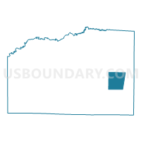
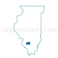
ASHLEY 2 Voting District, Washington County, Illinois
About
Outline

Summary
| Unique Area Identifier | 575109 |
| Name | ASHLEY 2 Voting District |
| County | Washington County |
| State | Illinois |
| Area (square miles) | 14.88 |
| Land Area (square miles) | 14.88 |
| Water Area (square miles) | 0.00 |
| % of Land Area | 100.00 |
| % of Water Area | 0.00 |
| Latitude of the Internal Point | 38.33207750 |
| Longtitude of the Internal Point | -89.22341990 |
Maps

Graphs
Select a template below for downloading or customizing gragh for ASHLEY 2 Voting District, Washington County, Illinois


Neighbors
Neighoring Voting District (by Name) Neighboring Voting District on the Map
- ASHLEY 1 Voting District, Washington County, IL
- BEAUCOUP Voting District, Washington County, IL
- BOLO Voting District, Washington County, IL
- DUBOIS 2 Voting District, Washington County, IL
- RICHVIEW Voting District, Washington County, IL
Top 10 Neighboring County Subdivision (by Population) Neighboring County Subdivision on the Map
- Ashley township, Washington County, IL (816)
- Du Bois township, Washington County, IL (748)
- Beaucoup township, Washington County, IL (593)
- Bolo township, Washington County, IL (419)
- Richview township, Washington County, IL (343)
Top 10 Neighboring Place (by Population) Neighboring Place on the Map
Top 10 Neighboring Elementary School District (by Population) Neighboring Elementary School District on the Map
- Nashville Consolidated Community School District 49, IL (5,553)
- Ashley Community Consolidated School District 15, IL (2,041)
Top 10 Neighboring Secondary School District (by Population) Neighboring Secondary School District on the Map
- Centralia High School District 200, IL (21,619)
- Nashville Community High School District 99, IL (8,925)