


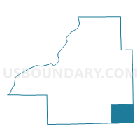
HITTLE Voting District, Tazewell County, Illinois
About
Outline

Summary
| Unique Area Identifier | 574941 |
| Name | HITTLE Voting District |
| County | Tazewell County |
| State | Illinois |
| Area (square miles) | 30.26 |
| Land Area (square miles) | 30.25 |
| Water Area (square miles) | 0.01 |
| % of Land Area | 99.97 |
| % of Water Area | 0.03 |
| Latitude of the Internal Point | 40.35075730 |
| Longtitude of the Internal Point | -89.32348310 |
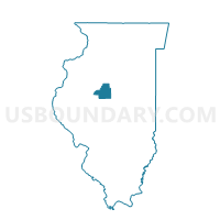
Maps

Graphs
Select a template below for downloading or customizing gragh for HITTLE Voting District, Tazewell County, Illinois


Neighbors
Neighoring Voting District (by Name) Neighboring Voting District on the Map
- ALLIN Voting District, McLean County, IL
- BOYNTON 1 Voting District, Tazewell County, IL
- EMINENCE Voting District, Logan County, IL
- HOPEDALE 1 Voting District, Tazewell County, IL
- LITTLE MACKINAW 2 Voting District, Tazewell County, IL
- MT HOPE Voting District, McLean County, IL
- ORVIL 1 Voting District, Logan County, IL
Top 10 Neighboring County Subdivision (by Population) Neighboring County Subdivision on the Map
- Hopedale township, Tazewell County, IL (1,913)
- Little Mackinaw township, Tazewell County, IL (1,575)
- Mount Hope township, McLean County, IL (1,103)
- Orvil township, Logan County, IL (1,068)
- Allin township, McLean County, IL (919)
- Hittle township, Tazewell County, IL (591)
- Eminence township, Logan County, IL (421)
- Boynton township, Tazewell County, IL (275)
Top 10 Neighboring Place (by Population) Neighboring Place on the Map
Top 10 Neighboring Unified School District (by Population) Neighboring Unified School District on the Map
Top 10 Neighboring State Legislative District Lower Chamber (by Population) Neighboring State Legislative District Lower Chamber on the Map
Top 10 Neighboring State Legislative District Upper Chamber (by Population) Neighboring State Legislative District Upper Chamber on the Map
Top 10 Neighboring 111th Congressional District (by Population) Neighboring 111th Congressional District on the Map
Top 10 Neighboring Census Tract (by Population) Neighboring Census Tract on the Map
- Census Tract 220, Tazewell County, IL (4,354)
- Census Tract 60, McLean County, IL (3,845)
- Census Tract 9529, Logan County, IL (3,759)
- Census Tract 9530, Logan County, IL (2,593)
Top 10 Neighboring 5-Digit ZIP Code Tabulation Area (by Population) Neighboring 5-Digit ZIP Code Tabulation Area on the Map
- 61734, IL (2,867)
- 61723, IL (2,321)
- 61747, IL (1,560)
- 61759, IL (1,534)
- 61754, IL (1,261)
- 61774, IL (962)
- 62635, IL (738)
- 61721, IL (613)