


BELLEVILLE 15 Voting District, St. Clair County, Illinois
About
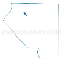
Outline

Summary
| Unique Area Identifier | 574329 |
| Name | BELLEVILLE 15 Voting District |
| County | St. Clair County |
| State | Illinois |
| Area (square miles) | 1.19 |
| Land Area (square miles) | 1.19 |
| Water Area (square miles) | 0.00 |
| % of Land Area | 100.00 |
| % of Water Area | 0.00 |
| Latitude of the Internal Point | 38.57744450 |
| Longtitude of the Internal Point | -90.04490900 |
Maps

Graphs
Select a template below for downloading or customizing gragh for BELLEVILLE 15 Voting District, St. Clair County, Illinois


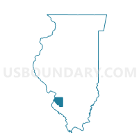
Neighbors
Neighoring Voting District (by Name) Neighboring Voting District on the Map
- BELLEVILLE 14 Voting District, St. Clair County, IL
- BELLEVILLE 30 Voting District, St. Clair County, IL
- CANTEEN 2 Voting District, St. Clair County, IL
- CASEYVILLE 14 Voting District, St. Clair County, IL
- EAST ST. LOUIS 36 Voting District, St. Clair County, IL
- ST CLAIR 9 Voting District, St. Clair County, IL
- STOOKEY 3 Voting District, St. Clair County, IL
Top 10 Neighboring County Subdivision (by Population) Neighboring County Subdivision on the Map
- Belleville township, St. Clair County, IL (44,478)
- St. Clair township, St. Clair County, IL (35,498)
- Caseyville township, St. Clair County, IL (31,996)
- East St. Louis township, St. Clair County, IL (27,006)
- Canteen township, St. Clair County, IL (10,263)
- Stookey township, St. Clair County, IL (10,007)
Top 10 Neighboring Place (by Population) Neighboring Place on the Map
- Belleville city, IL (44,478)
- East St. Louis city, IL (27,006)
- Fairview Heights city, IL (17,078)
- Swansea village, IL (13,430)
Top 10 Neighboring Elementary School District (by Population) Neighboring Elementary School District on the Map
- Belleville School District 118, IL (38,866)
- Harmony Emge School District 175, IL (10,847)
- Grant Community Consolidated School District 110, IL (7,972)
- Signal Hill School District 181, IL (3,232)
Top 10 Neighboring Secondary School District (by Population) Neighboring Secondary School District on the Map
Top 10 Neighboring Unified School District (by Population) Neighboring Unified School District on the Map
Top 10 Neighboring State Legislative District Lower Chamber (by Population) Neighboring State Legislative District Lower Chamber on the Map
Top 10 Neighboring State Legislative District Upper Chamber (by Population) Neighboring State Legislative District Upper Chamber on the Map
Top 10 Neighboring 111th Congressional District (by Population) Neighboring 111th Congressional District on the Map
Top 10 Neighboring Census Tract (by Population) Neighboring Census Tract on the Map
- Census Tract 5034.02, St. Clair County, IL (7,627)
- Census Tract 5033.22, St. Clair County, IL (7,148)
- Census Tract 5032.11, St. Clair County, IL (4,247)
- Census Tract 5024.04, St. Clair County, IL (4,161)
- Census Tract 5015.02, St. Clair County, IL (2,884)
- Census Tract 5014, St. Clair County, IL (2,790)
- Census Tract 5015.01, St. Clair County, IL (1,812)