


LEVEE 1 Voting District, Pike County, Illinois
About
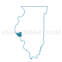
Outline

Summary
| Unique Area Identifier | 573989 |
| Name | LEVEE 1 Voting District |
| County | Pike County |
| State | Illinois |
| Area (square miles) | 25.03 |
| Land Area (square miles) | 22.02 |
| Water Area (square miles) | 3.01 |
| % of Land Area | 87.99 |
| % of Water Area | 12.01 |
| Latitude of the Internal Point | 39.72533820 |
| Longtitude of the Internal Point | -91.30656430 |
Maps


Graphs
Select a template below for downloading or customizing gragh for LEVEE 1 Voting District, Pike County, Illinois


Neighbors
Neighoring Voting District (by Name) Neighboring Voting District on the Map
- CINCINNATI 1 Voting District, Pike County, IL
- FALL CREEK 1 Voting District, Adams County, IL
- Fourth Ward Second Precinct, Marion County, MO
- KINDERHOOK 2 Voting District, Pike County, IL
- Mt. Zion Voting District, Marion County, MO
- PAYSON 1 Voting District, Adams County, IL
- Saverton Voting District, Ralls County, MO
- Second Ward First Precinct, Marion County, MO
Top 10 Neighboring County Subdivision (by Population) Neighboring County Subdivision on the Map
- Mason township, Marion County, MO (13,438)
- Miller township, Marion County, MO (5,997)
- Saverton township, Ralls County, MO (2,034)
- Payson township, Adams County, IL (1,795)
- Kinderhook township, Pike County, IL (840)
- Fall Creek township, Adams County, IL (529)
- Levee township, Pike County, IL (47)
- Cincinnati township, Pike County, IL (31)
Top 10 Neighboring Place (by Population) Neighboring Place on the Map
Top 10 Neighboring Unified School District (by Population) Neighboring Unified School District on the Map
- Hannibal School District, MO (22,813)
- Western Community Unit School District 12, IL (3,652)
- Payson Community Unit School District 1, IL (3,278)
Top 10 Neighboring State Legislative District Lower Chamber (by Population) Neighboring State Legislative District Lower Chamber on the Map
- State House District 93, IL (103,943)
- State House District 97, IL (103,784)
- State House District 6, MO (35,970)
Top 10 Neighboring State Legislative District Upper Chamber (by Population) Neighboring State Legislative District Upper Chamber on the Map
- State Senate District 49, IL (207,061)
- State Senate District 47, IL (203,948)
- State Senate District 18, MO (159,547)
Top 10 Neighboring 111th Congressional District (by Population) Neighboring 111th Congressional District on the Map
- Congressional District 9, MO (684,101)
- Congressional District 18, IL (665,723)
- Congressional District 17, IL (634,792)
Top 10 Neighboring Census Tract (by Population) Neighboring Census Tract on the Map
- Census Tract 103, Adams County, IL (5,890)
- Census Tract 106, Adams County, IL (5,875)
- Census Tract 9604, Marion County, MO (4,510)
- Census Tract 4701, Ralls County, MO (3,243)
- Census Tract 9608, Marion County, MO (3,231)
- Census Tract 9525, Pike County, IL (2,583)