


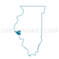
ATLAS 1 Voting District, Pike County, Illinois
About
Outline

Summary
| Unique Area Identifier | 573979 |
| Name | ATLAS 1 Voting District |
| County | Pike County |
| State | Illinois |
| Area (square miles) | 11.25 |
| Land Area (square miles) | 11.23 |
| Water Area (square miles) | 0.01 |
| % of Land Area | 99.87 |
| % of Water Area | 0.13 |
| Latitude of the Internal Point | 39.54466400 |
| Longtitude of the Internal Point | -90.94945050 |
Maps


Graphs
Select a template below for downloading or customizing gragh for ATLAS 1 Voting District, Pike County, Illinois


Neighbors
Neighoring Voting District (by Name) Neighboring Voting District on the Map
- ATLAS 2 Voting District, Pike County, IL
- ATLAS 3 Voting District, Pike County, IL
- DERRY 1 Voting District, Pike County, IL
- MARTINSBURG 2 Voting District, Pike County, IL
- PITTSFIELD 3 Voting District, Pike County, IL
Top 10 Neighboring County Subdivision (by Population) Neighboring County Subdivision on the Map
- Pittsfield township, Pike County, IL (4,477)
- Atlas township, Pike County, IL (563)
- Martinsburg township, Pike County, IL (419)
- Derry township, Pike County, IL (247)
Top 10 Neighboring Unified School District (by Population) Neighboring Unified School District on the Map
- Pikeland Community Unit School District 10, IL (8,636)
- Western Community Unit School District 12, IL (3,652)
- Pleasant Hill Community Unit School District 3, IL (1,771)