


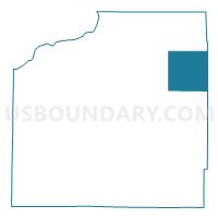
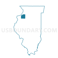
ALBA Voting District, Henry County, Illinois
About
Outline

Summary
| Unique Area Identifier | 571167 |
| Name | ALBA Voting District |
| County | Henry County |
| State | Illinois |
| Area (square miles) | 36.09 |
| Land Area (square miles) | 36.01 |
| Water Area (square miles) | 0.08 |
| % of Land Area | 99.77 |
| % of Water Area | 0.23 |
| Latitude of the Internal Point | 41.45827840 |
| Longtitude of the Internal Point | -89.91253820 |
Maps

Graphs
Select a template below for downloading or customizing gragh for ALBA Voting District, Henry County, Illinois


Neighbors
Neighoring Voting District (by Name) Neighboring Voting District on the Map
- ANNAWAN Voting District, Henry County, IL
- ATKINSON Voting District, Henry County, IL
- CORNWALL Voting District, Henry County, IL
- FAIRFIELD Voting District, Bureau County, IL
- GOLD Voting District, Bureau County, IL
- LORAINE Voting District, Henry County, IL
- MINERAL Voting District, Bureau County, IL
- YORKTOWN Voting District, Henry County, IL
Top 10 Neighboring County Subdivision (by Population) Neighboring County Subdivision on the Map
- Atkinson township, Henry County, IL (1,274)
- Annawan township, Henry County, IL (1,112)
- Mineral township, Bureau County, IL (484)
- Yorktown township, Henry County, IL (431)
- Fairfield township, Bureau County, IL (375)
- Loraine township, Henry County, IL (290)
- Cornwall township, Henry County, IL (278)
- Alba township, Henry County, IL (220)
- Gold township, Bureau County, IL (180)
Top 10 Neighboring Unified School District (by Population) Neighboring Unified School District on the Map
- Geneseo Community Unit School District 228, IL (16,118)
- Bureau Valley Community Unit School District 340, IL (6,788)
- Annawan Community Unit School District 226, IL (2,094)
Top 10 Neighboring State Legislative District Lower Chamber (by Population) Neighboring State Legislative District Lower Chamber on the Map
Top 10 Neighboring State Legislative District Upper Chamber (by Population) Neighboring State Legislative District Upper Chamber on the Map
Top 10 Neighboring 111th Congressional District (by Population) Neighboring 111th Congressional District on the Map
Top 10 Neighboring Census Tract (by Population) Neighboring Census Tract on the Map
- Census Tract 9648, Bureau County, IL (3,496)
- Census Tract 304, Henry County, IL (2,592)
- Census Tract 305, Henry County, IL (2,405)
Top 10 Neighboring 5-Digit ZIP Code Tabulation Area (by Population) Neighboring 5-Digit ZIP Code Tabulation Area on the Map
- 61254, IL (11,414)
- 61277, IL (3,355)
- 61283, IL (1,640)
- 61235, IL (1,391)
- 61234, IL (1,258)
- 61344, IL (374)