


BROOKSIDE 2 Voting District, Clinton County, Illinois
About
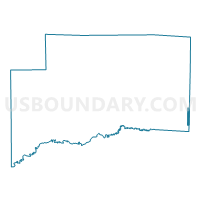
Outline

Summary
| Unique Area Identifier | 564932 |
| Name | BROOKSIDE 2 Voting District |
| County | Clinton County |
| State | Illinois |
| Area (square miles) | 0.77 |
| Land Area (square miles) | 0.77 |
| Water Area (square miles) | 0.00 |
| % of Land Area | 100.00 |
| % of Water Area | 0.00 |
| Latitude of the Internal Point | 38.54087130 |
| Longtitude of the Internal Point | -89.14518520 |
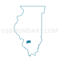
Maps

Graphs
Select a template below for downloading or customizing gragh for BROOKSIDE 2 Voting District, Clinton County, Illinois


Neighbors
Neighoring Voting District (by Name) Neighboring Voting District on the Map
- BROOKSIDE 3 Voting District, Clinton County, IL
- BROOKSIDE 4 Voting District, Clinton County, IL
- BROOKSIDE 5 Voting District, Clinton County, IL
- CENTRALIA 10 Voting District, Marion County, IL
- CENTRALIA 11 Voting District, Marion County, IL
- CENTRALIA 3 Voting District, Marion County, IL
- CENTRALIA 4 Voting District, Marion County, IL
- MERIDIAN Voting District, Clinton County, IL
- SANDOVAL 3 Voting District, Marion County, IL
Top 10 Neighboring County Subdivision (by Population) Neighboring County Subdivision on the Map
- Centralia township, Marion County, IL (15,042)
- Brookside township, Clinton County, IL (5,503)
- Sandoval township, Marion County, IL (2,322)
- Meridian township, Clinton County, IL (547)
Top 10 Neighboring Place (by Population) Neighboring Place on the Map
Top 10 Neighboring Elementary School District (by Population) Neighboring Elementary School District on the Map
- Centralia School District 135, IL (13,619)
- Central City School District 133, IL (2,255)
- Willow Grove School District 46, IL (2,053)
Top 10 Neighboring Secondary School District (by Population) Neighboring Secondary School District on the Map
Top 10 Neighboring Unified School District (by Population) Neighboring Unified School District on the Map
Top 10 Neighboring State Legislative District Lower Chamber (by Population) Neighboring State Legislative District Lower Chamber on the Map
Top 10 Neighboring State Legislative District Upper Chamber (by Population) Neighboring State Legislative District Upper Chamber on the Map
Top 10 Neighboring 111th Congressional District (by Population) Neighboring 111th Congressional District on the Map
Top 10 Neighboring Census Tract (by Population) Neighboring Census Tract on the Map
- Census Tract 9005, Clinton County, IL (6,799)
- Census Tract 9527, Marion County, IL (3,734)
- Census Tract 9525, Marion County, IL (2,819)
- Census Tract 9518, Marion County, IL (2,391)
- Census Tract 9526, Marion County, IL (2,178)
- Census Tract 9004.01, Clinton County, IL (1,329)