


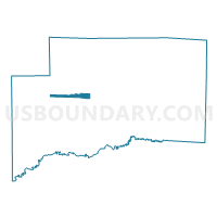
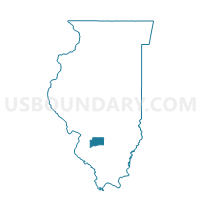
BREESE 1 Voting District, Clinton County, Illinois
About
Outline

Summary
| Unique Area Identifier | 564921 |
| Name | BREESE 1 Voting District |
| County | Clinton County |
| State | Illinois |
| Area (square miles) | 2.51 |
| Land Area (square miles) | 2.51 |
| Water Area (square miles) | 0.00 |
| % of Land Area | 100.00 |
| % of Water Area | 0.00 |
| Latitude of the Internal Point | 38.60980250 |
| Longtitude of the Internal Point | -89.52389720 |
Maps

Graphs
Select a template below for downloading or customizing gragh for BREESE 1 Voting District, Clinton County, Illinois


Neighbors
Neighoring Voting District (by Name) Neighboring Voting District on the Map
- BREESE 2 Voting District, Clinton County, IL
- BREESE 3 Voting District, Clinton County, IL
- BREESE 4 Voting District, Clinton County, IL
- SUGAR CREEK 1 Voting District, Clinton County, IL
- SUGAR CREEK 5 Voting District, Clinton County, IL
- WADE 1 Voting District, Clinton County, IL
- WADE 2 Voting District, Clinton County, IL
Top 10 Neighboring County Subdivision (by Population) Neighboring County Subdivision on the Map
- Sugar Creek township, Clinton County, IL (6,184)
- Breese township, Clinton County, IL (5,417)
- Wade township, Clinton County, IL (1,717)