


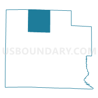
BLAIR Voting District, Clay County, Illinois
About
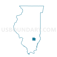
Outline

Summary
| Unique Area Identifier | 564902 |
| Name | BLAIR Voting District |
| County | Clay County |
| State | Illinois |
| Area (square miles) | 36.22 |
| Land Area (square miles) | 36.22 |
| Water Area (square miles) | 0.00 |
| % of Land Area | 100.00 |
| % of Water Area | 0.00 |
| Latitude of the Internal Point | 38.86998740 |
| Longtitude of the Internal Point | -88.52556250 |
Maps

Graphs
Select a template below for downloading or customizing gragh for BLAIR Voting District, Clay County, Illinois


Neighbors
Neighoring Voting District (by Name) Neighboring Voting District on the Map
- BIBLE GROVE Voting District, Clay County, IL
- HOOSIER Voting District, Clay County, IL
- LARKINSBURG I Voting District, Clay County, IL
- LARKINSBURG II Voting District, Clay County, IL
- LOUISVILLE I Voting District, Clay County, IL
- LOUISVILLE II Voting District, Clay County, IL
- LUCAS Voting District, Effingham County, IL
- MASON 1 Voting District, Effingham County, IL
- OSKALOOSA Voting District, Clay County, IL
- UNION Voting District, Effingham County, IL
Top 10 Neighboring County Subdivision (by Population) Neighboring County Subdivision on the Map
- Louisville township, Clay County, IL (1,662)
- Mason township, Effingham County, IL (1,364)
- Union township, Effingham County, IL (742)
- Larkinsburg township, Clay County, IL (644)
- Blair township, Clay County, IL (636)
- Lucas township, Effingham County, IL (495)
- Bible Grove township, Clay County, IL (344)
- Hoosier township, Clay County, IL (338)
- Oskaloosa township, Clay County, IL (322)
Top 10 Neighboring Unified School District (by Population) Neighboring Unified School District on the Map
- Effingham Community Unit School District 40, IL (20,287)
- North Clay Community Unit School District 25, IL (3,867)
- Dieterich Community Unit School District 30, IL (2,307)
Top 10 Neighboring State Legislative District Lower Chamber (by Population) Neighboring State Legislative District Lower Chamber on the Map
Top 10 Neighboring State Legislative District Upper Chamber (by Population) Neighboring State Legislative District Upper Chamber on the Map
Top 10 Neighboring 111th Congressional District (by Population) Neighboring 111th Congressional District on the Map
Top 10 Neighboring Census Tract (by Population) Neighboring Census Tract on the Map
- Census Tract 9505, Effingham County, IL (4,272)
- Census Tract 9504, Effingham County, IL (3,867)
- Census Tract 9719, Clay County, IL (2,517)