


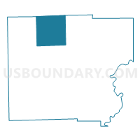
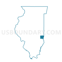
DOLSON Voting District, Clark County, Illinois
About
Outline

Summary
| Unique Area Identifier | 564873 |
| Name | DOLSON Voting District |
| County | Clark County |
| State | Illinois |
| Area (square miles) | 35.73 |
| Land Area (square miles) | 34.48 |
| Water Area (square miles) | 1.25 |
| % of Land Area | 96.50 |
| % of Water Area | 3.50 |
| Latitude of the Internal Point | 39.43299180 |
| Longtitude of the Internal Point | -87.84166060 |
Maps

Graphs
Select a template below for downloading or customizing gragh for DOLSON Voting District, Clark County, Illinois


Neighbors
Neighoring Voting District (by Name) Neighboring Voting District on the Map
- AUBURN Voting District, Clark County, IL
- DOUGLAS Voting District, Clark County, IL
- GRANDVIEW Voting District, Edgar County, IL
- KANSAS 1 Voting District, Edgar County, IL
- MARSHALL 2 Voting District, Clark County, IL
- MARTINSVILLE 1 Voting District, Clark County, IL
- PARKER Voting District, Clark County, IL
- WESTFIELD Voting District, Clark County, IL
Top 10 Neighboring County Subdivision (by Population) Neighboring County Subdivision on the Map
- Marshall township, Clark County, IL (4,574)
- Martinsville township, Clark County, IL (1,602)
- Kansas township, Edgar County, IL (1,003)
- Westfield township, Clark County, IL (720)
- Grandview township, Edgar County, IL (590)
- Dolson township, Clark County, IL (353)
- Auburn township, Clark County, IL (242)
- Parker township, Clark County, IL (186)
- Douglas township, Clark County, IL (168)
Top 10 Neighboring Unified School District (by Population) Neighboring Unified School District on the Map
- Marshall Community Unit School District 2C, IL (8,125)
- Casey-Westfield Community Unit School District 4C, IL (6,073)
- Paris Community Unit School District 4, IL (4,747)
- Martinsville Community Unit School District 3C, IL (2,401)
- Kansas Community Unit School District 3, IL (1,420)
Top 10 Neighboring State Legislative District Lower Chamber (by Population) Neighboring State Legislative District Lower Chamber on the Map
Top 10 Neighboring State Legislative District Upper Chamber (by Population) Neighboring State Legislative District Upper Chamber on the Map
Top 10 Neighboring 111th Congressional District (by Population) Neighboring 111th Congressional District on the Map
Top 10 Neighboring Census Tract (by Population) Neighboring Census Tract on the Map
- Census Tract 601, Clark County, IL (4,834)
- Census Tract 705, Edgar County, IL (4,050)
- Census Tract 604, Clark County, IL (1,793)