


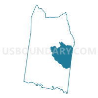
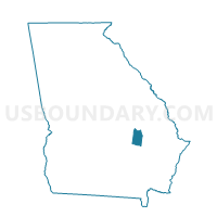
27939 - 39 NEWBRANCH Voting District, Toombs County, Georgia
About
Outline

Summary
| Unique Area Identifier | 562972 |
| Name | 27939 - 39 NEWBRANCH Voting District |
| County | Toombs County |
| State | Georgia |
| Area (square miles) | 43.20 |
| Land Area (square miles) | 42.61 |
| Water Area (square miles) | 0.59 |
| % of Land Area | 98.63 |
| % of Water Area | 1.37 |
| Latitude of the Internal Point | 32.10348690 |
| Longtitude of the Internal Point | -82.25276950 |
Maps

Graphs
Select a template below for downloading or customizing gragh for 27939 - 39 NEWBRANCH Voting District, Toombs County, Georgia


Neighbors
Neighoring Voting District (by Name) Neighboring Voting District on the Map
- 2675 - DISTRICT II Voting District, Tattnall County, GA
- 2679 - DISTRICT V Voting District, Tattnall County, GA
- 2791403 - 1403 MARVIN Voting District, Toombs County, GA
- 2791521 - 1521 HARDEN Voting District, Toombs County, GA
- 27915362 - 15362 SANTA CLAUS Voting District, Toombs County, GA
- 2791770 - 1770 OHOOPEE Voting District, Toombs County, GA
Top 10 Neighboring County Subdivision (by Population) Neighboring County Subdivision on the Map
- Vidalia-Lyons CCD, Toombs County, GA (23,867)
- Reidsville CCD, Tattnall County, GA (11,003)
- Cedar Crossing CCD, Toombs County, GA (3,356)
Top 10 Neighboring Unified School District (by Population) Neighboring Unified School District on the Map
Top 10 Neighboring State Legislative District Lower Chamber (by Population) Neighboring State Legislative District Lower Chamber on the Map
Top 10 Neighboring State Legislative District Upper Chamber (by Population) Neighboring State Legislative District Upper Chamber on the Map
Top 10 Neighboring 111th Congressional District (by Population) Neighboring 111th Congressional District on the Map
Top 10 Neighboring Census Tract (by Population) Neighboring Census Tract on the Map
- Census Tract 9502.02, Tattnall County, GA (5,133)
- Census Tract 9701, Toombs County, GA (4,952)
- Census Tract 9705, Toombs County, GA (3,814)
- Census Tract 9706, Toombs County, GA (3,356)