


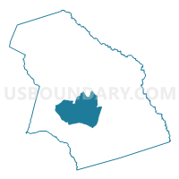
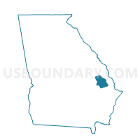
03110 - EMIT Voting District, Bulloch County, Georgia
About
Outline

Summary
| Unique Area Identifier | 560406 |
| Name | 03110 - EMIT Voting District |
| County | Bulloch County |
| State | Georgia |
| Area (square miles) | 47.03 |
| Land Area (square miles) | 45.82 |
| Water Area (square miles) | 1.21 |
| % of Land Area | 97.42 |
| % of Water Area | 2.58 |
| Latitude of the Internal Point | 32.34174380 |
| Longtitude of the Internal Point | -81.76958900 |
Maps

Graphs
Select a template below for downloading or customizing gragh for 03110 - EMIT Voting District, Bulloch County, Georgia


Neighbors
Neighoring Voting District (by Name) Neighboring Voting District on the Map
- 03113 - FAIR Voting District, Bulloch County, GA
- 0314 - BROOKLET Voting District, Bulloch County, GA
- 0317 - NEVILS Voting District, Bulloch County, GA
- 0318 - SINKHOLE Voting District, Bulloch County, GA
- 0319 - REGISTER Voting District, Bulloch County, GA
Top 10 Neighboring County Subdivision (by Population) Neighboring County Subdivision on the Map
- Statesboro CCD, Bulloch County, GA (47,688)
- Brooklet CCD, Bulloch County, GA (9,056)
- Nevils-Stilson CCD, Bulloch County, GA (6,950)
- Register CCD, Bulloch County, GA (2,542)
Top 10 Neighboring Unified School District (by Population) Neighboring Unified School District on the Map
Top 10 Neighboring State Legislative District Lower Chamber (by Population) Neighboring State Legislative District Lower Chamber on the Map
Top 10 Neighboring State Legislative District Upper Chamber (by Population) Neighboring State Legislative District Upper Chamber on the Map
Top 10 Neighboring 111th Congressional District (by Population) Neighboring 111th Congressional District on the Map
Top 10 Neighboring Census Tract (by Population) Neighboring Census Tract on the Map
- Census Tract 1107, Bulloch County, GA (9,197)
- Census Tract 1103, Bulloch County, GA (7,988)
- Census Tract 1109, Bulloch County, GA (6,950)
- Census Tract 1104.03, Bulloch County, GA (6,801)
- Census Tract 1105, Bulloch County, GA (4,045)
- Census Tract 1108, Bulloch County, GA (2,542)