


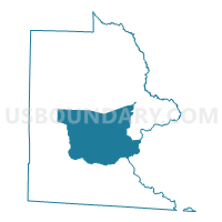
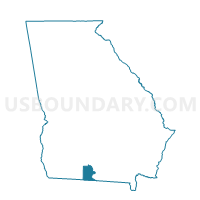
0271199 - QUITMAN Voting District, Brooks County, Georgia
About
Outline

Summary
| Unique Area Identifier | 560382 |
| Name | 0271199 - QUITMAN Voting District |
| County | Brooks County |
| State | Georgia |
| Area (square miles) | 78.09 |
| Land Area (square miles) | 77.18 |
| Water Area (square miles) | 0.91 |
| % of Land Area | 98.83 |
| % of Water Area | 1.17 |
| Latitude of the Internal Point | 30.81435540 |
| Longtitude of the Internal Point | -83.55696160 |
Maps

Graphs
Select a template below for downloading or customizing gragh for 0271199 - QUITMAN Voting District, Brooks County, Georgia


Neighbors
Neighoring Voting District (by Name) Neighboring Voting District on the Map
- 0271198 - GROOVERVILLE Voting District, Brooks County, GA
- 0271230 - DRY LAKE Voting District, Brooks County, GA
- 0271402 - DIXIE Voting District, Brooks County, GA
- 0271571 - BARNEY Voting District, Brooks County, GA
- 0271650 - BRIGGS Voting District, Brooks County, GA
- 027659 - NANKIN Voting District, Brooks County, GA
- 027660 - MORVEN Voting District, Brooks County, GA
- 18524 - RAINWATER CONFERENCE CENTER Voting District, Lowndes County, GA
- 18528 - MT ZION CHURCH Voting District, Lowndes County, GA
Top 10 Neighboring County Subdivision (by Population) Neighboring County Subdivision on the Map
- Valdosta CCD, Lowndes County, GA (70,162)
- Quitman CCD, Brooks County, GA (6,177)
- Morven CCD, Brooks County, GA (4,890)
- Barwick-Pavo CCD, Brooks County, GA (1,660)
- Dixie CCD, Brooks County, GA (1,488)
- Empress CCD, Brooks County, GA (1,117)
Top 10 Neighboring Place (by Population) Neighboring Place on the Map
Top 10 Neighboring Unified School District (by Population) Neighboring Unified School District on the Map
Top 10 Neighboring State Legislative District Lower Chamber (by Population) Neighboring State Legislative District Lower Chamber on the Map
Top 10 Neighboring State Legislative District Upper Chamber (by Population) Neighboring State Legislative District Upper Chamber on the Map
Top 10 Neighboring 111th Congressional District (by Population) Neighboring 111th Congressional District on the Map
Top 10 Neighboring Census Tract (by Population) Neighboring Census Tract on the Map
- Census Tract 114.03, Lowndes County, GA (8,253)
- Census Tract 9603, Brooks County, GA (5,801)
- Census Tract 9604, Brooks County, GA (3,601)
- Census Tract 9606, Brooks County, GA (2,605)
- Census Tract 9605, Brooks County, GA (2,576)
- Census Tract 114.01, Lowndes County, GA (2,173)
- Census Tract 9602, Brooks County, GA (1,660)