


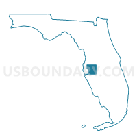
917-Voting District, Hillsborough County, Florida
About
Outline

Summary
| Unique Area Identifier | 554069 |
| Name | 917-Voting District |
| County | Hillsborough County |
| State | Florida |
| Area (square miles) | 90.08 |
| Land Area (square miles) | 83.38 |
| Water Area (square miles) | 6.71 |
| % of Land Area | 92.55 |
| % of Water Area | 7.45 |
| Latitude of the Internal Point | 27.71976810 |
| Longtitude of the Internal Point | -82.13056630 |
Maps


Graphs
Select a template below for downloading or customizing gragh for 917-Voting District, Hillsborough County, Florida


Neighbors
Neighoring Voting District (by Name) Neighboring Voting District on the Map
- 1-Voting District, Hardee County, FL
- 4-Voting District, Manatee County, FL
- 512-Voting District, Polk County, FL
- 705-Voting District, Hillsborough County, FL
- 913-Voting District, Hillsborough County, FL
- 918-Voting District, Hillsborough County, FL
- 919-Voting District, Hillsborough County, FL
Top 10 Neighboring County Subdivision (by Population) Neighboring County Subdivision on the Map
- Wimauma-Riverview CCD, Hillsborough County, FL (123,563)
- Bartow CCD, Polk County, FL (61,093)
- Parrish CCD, Manatee County, FL (22,183)
- Bowling Green CCD, Hardee County, FL (5,069)
Top 10 Neighboring Unified School District (by Population) Neighboring Unified School District on the Map
- Hillsborough County School District, FL (1,229,226)
- Polk County School District, FL (602,095)
- Manatee County School District, FL (322,833)
- Hardee County School District, FL (27,731)
Top 10 Neighboring State Legislative District Lower Chamber (by Population) Neighboring State Legislative District Lower Chamber on the Map
- State House District 67, FL (241,034)
- State House District 66, FL (162,026)
- State House District 63, FL (156,183)
Top 10 Neighboring State Legislative District Upper Chamber (by Population) Neighboring State Legislative District Upper Chamber on the Map
- State Senate District 10, FL (565,921)
- State Senate District 21, FL (529,870)
- State Senate District 17, FL (456,960)
Top 10 Neighboring 111th Congressional District (by Population) Neighboring 111th Congressional District on the Map
- Congressional District 12, FL (842,199)
- Congressional District 13, FL (757,805)
- Congressional District 9, FL (753,549)
Top 10 Neighboring Census Tract (by Population) Neighboring Census Tract on the Map
- Census Tract 139.20, Hillsborough County, FL (4,007)
- Census Tract 139.03, Hillsborough County, FL (3,419)
- Census Tract 19.14, Manatee County, FL (2,899)
- Census Tract 139.07, Hillsborough County, FL (2,141)
- Census Tract 161, Polk County, FL (1,258)
- Census Tract 9702.02, Hardee County, FL (959)