


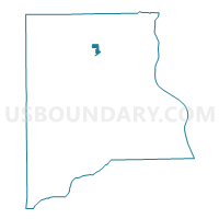
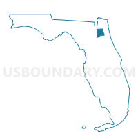
110A-Voting District, Clay County, Florida
About
Outline

Summary
| Unique Area Identifier | 552491 |
| Name | 110A-Voting District |
| County | Clay County |
| State | Florida |
| Area (square miles) | 0.91 |
| Land Area (square miles) | 0.91 |
| Water Area (square miles) | 0.00 |
| % of Land Area | 100.00 |
| % of Water Area | 0.00 |
| Latitude of the Internal Point | 30.10076550 |
| Longtitude of the Internal Point | -81.85335500 |
Maps

Graphs
Select a template below for downloading or customizing gragh for 110A-Voting District, Clay County, Florida


Neighbors
Neighoring Voting District (by Name) Neighboring Voting District on the Map
- 110-Voting District, Clay County, FL
- 110B-Voting District, Clay County, FL
- 110RWT-Voting District (Ridgewood Trails CDD), Clay County, FL
- 112-Voting District, Clay County, FL
- 502-Voting District, Clay County, FL