


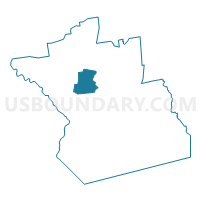
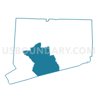
Bethany 1 Voting District, New Haven County, Connecticut
About
Outline

Summary
| Unique Area Identifier | 549967 |
| Name | Bethany 1 Voting District |
| County | New Haven County |
| State | Connecticut |
| Area (square miles) | 21.51 |
| Land Area (square miles) | 21.13 |
| Water Area (square miles) | 0.38 |
| % of Land Area | 98.21 |
| % of Water Area | 1.79 |
| Latitude of the Internal Point | 41.42296400 |
| Longtitude of the Internal Point | -72.99418710 |
Maps

Graphs
Select a template below for downloading or customizing gragh for Bethany 1 Voting District, New Haven County, Connecticut


Neighbors
Neighoring Voting District (by Name) Neighboring Voting District on the Map
- Beacon Falls 1 Voting District, New Haven County, CT
- Cheshire 4 Voting District, New Haven County, CT
- Hamden 11 Voting District, New Haven County, CT
- Hamden 9 Voting District, New Haven County, CT
- Naugatuck 2-2 Voting District, New Haven County, CT
- Naugatuck 2-3 Voting District, New Haven County, CT
- Prospect 89-1 Voting District, New Haven County, CT
- Seymour 3 Voting District, New Haven County, CT
- Woodbridge 1 Voting District, New Haven County, CT
Top 10 Neighboring County Subdivision (by Population) Neighboring County Subdivision on the Map
- Hamden town, New Haven County, CT (60,960)
- Naugatuck town, New Haven County, CT (31,862)
- Cheshire town, New Haven County, CT (29,261)
- Seymour town, New Haven County, CT (16,540)
- Prospect town, New Haven County, CT (9,405)
- Woodbridge town, New Haven County, CT (8,990)
- Beacon Falls town, New Haven County, CT (6,049)
- Bethany town, New Haven County, CT (5,563)
Top 10 Neighboring Place (by Population) Neighboring Place on the Map
Top 10 Neighboring Elementary School District (by Population) Neighboring Elementary School District on the Map
Top 10 Neighboring Secondary School District (by Population) Neighboring Secondary School District on the Map
Top 10 Neighboring Unified School District (by Population) Neighboring Unified School District on the Map
- Hamden School District, CT (60,960)
- Naugatuck School District, CT (31,862)
- Cheshire School District, CT (29,261)
- Seymour School District, CT (16,540)
- Regional School District 16, CT (15,454)
Top 10 Neighboring State Legislative District Lower Chamber (by Population) Neighboring State Legislative District Lower Chamber on the Map
- State House District 105, CT (24,797)
- State House District 88, CT (24,771)
- State House District 89, CT (23,436)
- State House District 103, CT (22,818)
- State House District 70, CT (22,757)
- State House District 114, CT (22,623)
Top 10 Neighboring State Legislative District Upper Chamber (by Population) Neighboring State Legislative District Upper Chamber on the Map
- State Senate District 13, CT (101,659)
- State Senate District 32, CT (101,305)
- State Senate District 11, CT (99,359)
- State Senate District 15, CT (96,274)
- State Senate District 17, CT (95,979)
Top 10 Neighboring 111th Congressional District (by Population) Neighboring 111th Congressional District on the Map
Top 10 Neighboring Census Tract (by Population) Neighboring Census Tract on the Map
- Census Tract 1659, New Haven County, CT (7,897)
- Census Tract 3434, New Haven County, CT (6,740)
- Census Tract 3411, New Haven County, CT (6,049)
- Census Tract 1611, New Haven County, CT (5,563)
- Census Tract 1602, New Haven County, CT (5,547)
- Census Tract 3471, New Haven County, CT (5,527)
- Census Tract 1301.01, New Haven County, CT (4,911)
- Census Tract 3452.02, New Haven County, CT (4,229)
- Census Tract 1658.02, New Haven County, CT (4,086)
- Census Tract 3472, New Haven County, CT (3,878)
Top 10 Neighboring 5-Digit ZIP Code Tabulation Area (by Population) Neighboring 5-Digit ZIP Code Tabulation Area on the Map
- 06770, CT (31,975)
- 06410, CT (29,161)
- 06514, CT (26,265)
- 06518, CT (19,848)
- 06483, CT (16,540)
- 06712, CT (9,376)
- 06525, CT (8,990)
- 06403, CT (6,033)
- 06524, CT (5,563)