


Voting Districts not defined, Fairfield County, Connecticut
About
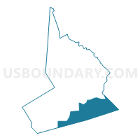
Outline

Summary
| Unique Area Identifier | 549549 |
| Name | Voting Districts not defined |
| County | Fairfield County |
| State | Connecticut |
| Area (square miles) | 116.63 |
| Land Area (square miles) | 0.00 |
| Water Area (square miles) | 116.63 |
| % of Land Area | 0.00 |
| % of Water Area | 100.00 |
| Latitude of the Internal Point | 41.07794710 |
| Longtitude of the Internal Point | -73.21651840 |
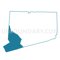
Maps

Graphs
Select a template below for downloading or customizing gragh for Voting Districts not defined, Fairfield County, Connecticut


Neighbors
Neighoring Voting District (by Name) Neighboring Voting District on the Map
- Voting District 0200000, Suffolk County, NY
- Voting District 0400000, Suffolk County, NY
- Voting District 0513004, Nassau County, NY
- Voting District 0800000, Suffolk County, NY
- Bridgeport 12403 Voting District, Fairfield County, CT
- Bridgeport 12904 Voting District, Fairfield County, CT
- Bridgeport 13003 Voting District, Fairfield County, CT
- Darien 2 Voting District, Fairfield County, CT
- Fairfield 1-132 Voting District, Fairfield County, CT
- Fairfield 10-132 Voting District, Fairfield County, CT
- Norwalk 137A Voting District, Fairfield County, CT
- Stratford Baldwin Voting District, Fairfield County, CT
- Stratford Lordship Voting District, Fairfield County, CT
- Voting Districts not defined, New Haven County, CT
- Westport 133-1 Voting District, Fairfield County, CT
- Westport 136-1 Voting District, Fairfield County, CT
Top 10 Neighboring County Subdivision (by Population) Neighboring County Subdivision on the Map
- Brookhaven town, Suffolk County, NY (486,040)
- Oyster Bay town, Nassau County, NY (293,214)
- Huntington town, Suffolk County, NY (203,264)
- Bridgeport town, Fairfield County, CT (144,229)
- Smithtown town, Suffolk County, NY (117,801)
- Norwalk town, Fairfield County, CT (85,603)
- Fairfield town, Fairfield County, CT (59,404)
- Stratford town, Fairfield County, CT (51,384)
- Westport town, Fairfield County, CT (26,391)
- Darien town, Fairfield County, CT (20,732)
Top 10 Neighboring Place (by Population) Neighboring Place on the Map
- Bridgeport city, CT (144,229)
- Norwalk city, CT (85,603)
- Stratford CDP, CT (51,384)
- Westport CDP, CT (26,391)
- Darien CDP, CT (20,732)
- Southport CDP, CT (1,585)
Top 10 Neighboring Unified School District (by Population) Neighboring Unified School District on the Map
- Bridgeport School District, CT (144,229)
- Norwalk School District, CT (85,603)
- Fairfield School District, CT (59,404)
- Smithtown Central School District, NY (57,142)
- Stratford School District, CT (51,384)
- Three Village Central School District, NY (48,424)
- Northport-East Northport Union Free School District, NY (36,113)
- Westport School District, CT (26,391)
- Kings Park Central School District, NY (22,894)
- Darien School District, CT (20,732)
Top 10 Neighboring State Legislative District Lower Chamber (by Population) Neighboring State Legislative District Lower Chamber on the Map
- Assembly District 4, NY (137,024)
- Assembly District 7, NY (134,480)
- Assembly District 13, NY (131,694)
- Assembly District 9, NY (130,285)
- State House District 141, CT (24,805)
- State House District 133, CT (24,556)
- State House District 129, CT (24,361)
- State House District 132, CT (24,317)
- State House District 136, CT (24,123)
- State House District 124, CT (23,959)
Top 10 Neighboring State Legislative District Upper Chamber (by Population) Neighboring State Legislative District Upper Chamber on the Map
- State Senate District 1, NY (341,254)
- State Senate District 5, NY (316,844)
- State Senate District 2, NY (314,159)
- State Senate District 27, CT (103,721)
- State Senate District 28, CT (103,194)
- State Senate District 26, CT (102,047)
- State Senate District 22, CT (101,713)
- State Senate District 25, CT (99,794)
- State Senate District 21, CT (96,683)
- State Senate District 23, CT (95,642)
Top 10 Neighboring 111th Congressional District (by Population) Neighboring 111th Congressional District on the Map
- Congressional District 3, CT (712,339)
- Congressional District 4, CT (706,740)
- Congressional District 1, NY (705,559)
- Congressional District 2, NY (679,893)
- Congressional District 3, NY (645,508)
Top 10 Neighboring Census Tract (by Population) Neighboring Census Tract on the Map
- Census Tract 701, Fairfield County, CT (5,021)
- Census Tract 616, Fairfield County, CT (4,964)
- Census Tract 615, Fairfield County, CT (4,692)
- Census Tract 744, Fairfield County, CT (4,168)
- Census Tract 506, Fairfield County, CT (3,348)
- Census Tract 805, Fairfield County, CT (3,189)
- Census Tract 504, Fairfield County, CT (2,341)
- Census Tract 606, Fairfield County, CT (2,336)
- Census Tract 704, Fairfield County, CT (1,693)
- Census Tract 9900, Fairfield County, CT (0)
Top 10 Neighboring 5-Digit ZIP Code Tabulation Area (by Population) Neighboring 5-Digit ZIP Code Tabulation Area on the Map
- 06824, CT (33,900)
- 06604, CT (30,313)
- 06880, CT (26,647)
- 06605, CT (23,397)
- 06615, CT (18,453)
- 06607, CT (7,843)
- 06890, CT (4,306)