


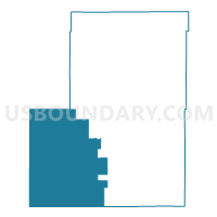
Washington 5, Washington County, Colorado
About
Outline

Summary
| Unique Area Identifier | 549304 |
| Name | Washington 5 |
| County | Washington County |
| State | Colorado |
| Area (square miles) | 629.09 |
| Land Area (square miles) | 627.85 |
| Water Area (square miles) | 1.24 |
| % of Land Area | 99.80 |
| % of Water Area | 0.20 |
| Latitude of the Internal Point | 39.76401740 |
| Longtitude of the Internal Point | -103.50195880 |
Maps


Graphs
Select a template below for downloading or customizing gragh for Washington 5, Washington County, Colorado


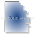

Neighbors
Neighoring Voting District (by Name) Neighboring Voting District on the Map
- Adams 215, Adams County, CO
- Arapahoe 334, Arapahoe County, CO
- Lincoln 2, Lincoln County, CO
- Lincoln 4, Lincoln County, CO
- Lincoln 6, Lincoln County, CO
- Morgan 16, Morgan County, CO
- Washington 2, Washington County, CO
- Washington 6, Washington County, CO
Top 10 Neighboring County Subdivision (by Population) Neighboring County Subdivision on the Map
- East Arapahoe CCD, Arapahoe County, CO (23,477)
- East Adams CCD, Adams County, CO (8,667)
- Brush CCD, Morgan County, CO (8,297)
- Limon CCD, Lincoln County, CO (3,363)
- Akron CCD, Washington County, CO (2,672)
- Woodlin CCD, Washington County, CO (478)
- Arriba CCD, Lincoln County, CO (400)
Top 10 Neighboring Unified School District (by Population) Neighboring Unified School District on the Map
- Fort Morgan School District RE-3, CO (16,956)
- Brush School District RE-2J, CO (8,114)
- Limon School District RE-4J, CO (3,314)
- Byers School District 32J, CO (2,469)
- Akron School District R-1, CO (2,453)
- Genoa-Hugo School District C-113, CO (1,348)
- Arriba-Flagler School District C-20, CO (1,141)
- Deer Trail School District 26J, CO (896)
- Arickaree School District R-2, CO (629)
- Woodlin School District R-104, CO (399)
Top 10 Neighboring State Legislative District Lower Chamber (by Population) Neighboring State Legislative District Lower Chamber on the Map
Top 10 Neighboring State Legislative District Upper Chamber (by Population) Neighboring State Legislative District Upper Chamber on the Map
- State Senate District 27, CO (188,185)
- State Senate District 25, CO (181,050)
- State Senate District 1, CO (125,154)
Top 10 Neighboring 111th Congressional District (by Population) Neighboring 111th Congressional District on the Map
- Congressional District 6, CO (797,813)
- Congressional District 4, CO (725,041)
- Congressional District 7, CO (678,410)
Top 10 Neighboring Census Tract (by Population) Neighboring Census Tract on the Map
- Census Tract 71.01, Arapahoe County, CO (5,107)
- Census Tract 84.02, Adams County, CO (4,352)
- Census Tract 9617, Lincoln County, CO (3,363)
- Census Tract 9242, Washington County, CO (2,665)
- Census Tract 9241, Washington County, CO (2,149)
- Census Tract 9618, Lincoln County, CO (2,104)
- Census Tract 8, Morgan County, CO (1,809)
Top 10 Neighboring 5-Digit ZIP Code Tabulation Area (by Population) Neighboring 5-Digit ZIP Code Tabulation Area on the Map
- 80701, CO (16,042)
- 80723, CO (7,179)
- 80828, CO (3,341)
- 80720, CO (2,558)
- 80105, CO (1,171)
- 80815, CO (911)
- 80818, CO (343)
- 80804, CO (327)
- 80757, CO (255)
- 80801, CO (154)