


Park 3, Park County, Colorado
About
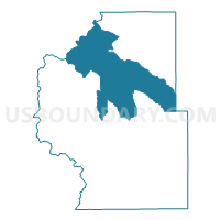
Outline

Summary
| Unique Area Identifier | 549042 |
| Name | Park 3 |
| County | Park County |
| State | Colorado |
| Area (square miles) | 407.39 |
| Land Area (square miles) | 406.35 |
| Water Area (square miles) | 1.03 |
| % of Land Area | 99.75 |
| % of Water Area | 0.25 |
| Latitude of the Internal Point | 39.27796050 |
| Longtitude of the Internal Point | -105.73221110 |
Maps


Graphs
Select a template below for downloading or customizing gragh for Park 3, Park County, Colorado


Neighbors
Neighoring Voting District (by Name) Neighboring Voting District on the Map
- 6222530007, Jefferson County, CO
- Park 1, Park County, CO
- Park 4, Park County, CO
- Park 5, Park County, CO
- Park 7, Park County, CO
- Summit 3, Summit County, CO
- Summit 4, Summit County, CO
- Summit 5, Summit County, CO
- Summit 7, Summit County, CO
Top 10 Neighboring County Subdivision (by Population) Neighboring County Subdivision on the Map
- South Jefferson CCD, Jefferson County, CO (24,885)
- Breckenridge CCD, Summit County, CO (16,599)
- Fairplay CCD, Park County, CO (14,027)
- Lake George CCD, Park County, CO (2,179)
Top 10 Neighboring Unified School District (by Population) Neighboring Unified School District on the Map
- Jefferson County School District R-1, CO (537,431)
- Summit School District RE-1, CO (27,852)
- Platte Canyon School District 1, CO (9,244)
- Park County School District RE-2, CO (6,962)
Top 10 Neighboring State Legislative District Lower Chamber (by Population) Neighboring State Legislative District Lower Chamber on the Map
- State House District 56, CO (79,238)
- State House District 25, CO (72,603)
- State House District 60, CO (72,008)
Top 10 Neighboring State Legislative District Upper Chamber (by Population) Neighboring State Legislative District Upper Chamber on the Map
- State Senate District 4, CO (180,522)
- State Senate District 16, CO (136,132)
- State Senate District 22, CO (127,842)
Top 10 Neighboring 111th Congressional District (by Population) Neighboring 111th Congressional District on the Map
- Congressional District 6, CO (797,813)
- Congressional District 2, CO (733,805)
- Congressional District 5, CO (725,902)
Top 10 Neighboring Census Tract (by Population) Neighboring Census Tract on the Map
- Census Tract 2, Summit County, CO (7,285)
- Census Tract 1, Park County, CO (5,587)
- Census Tract 4.02, Summit County, CO (5,373)
- Census Tract 4.01, Summit County, CO (4,254)
- Census Tract 120.58, Jefferson County, CO (3,660)
- Census Tract 2, Park County, CO (3,647)
- Census Tract 5, Park County, CO (2,179)
- Census Tract 4, Park County, CO (2,099)
Top 10 Neighboring 5-Digit ZIP Code Tabulation Area (by Population) Neighboring 5-Digit ZIP Code Tabulation Area on the Map
- 80424, CO (9,627)
- 80435, CO (7,278)
- 80135, CO (3,833)
- 80470, CO (3,287)
- 80440, CO (2,422)
- 80449, CO (909)
- 80456, CO (620)
- 80827, CO (549)
- 80432, CO (439)
- 80448, CO (193)