


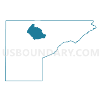
Mesa 42, Mesa County, Colorado
About
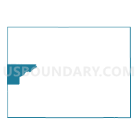
Outline

Summary
| Unique Area Identifier | 548890 |
| Name | Mesa 42 |
| County | Mesa County |
| State | Colorado |
| Area (square miles) | 151.47 |
| Land Area (square miles) | 151.47 |
| Water Area (square miles) | 0.00 |
| % of Land Area | 100.00 |
| % of Water Area | 0.00 |
| Latitude of the Internal Point | 39.19415030 |
| Longtitude of the Internal Point | -108.49408150 |
Maps

Graphs
Select a template below for downloading or customizing gragh for Mesa 42, Mesa County, Colorado


Neighbors
Neighoring Voting District (by Name) Neighboring Voting District on the Map
- Mesa 36, Mesa County, CO
- Mesa 37, Mesa County, CO
- Mesa 40, Mesa County, CO
- Mesa 41, Mesa County, CO
- Mesa 43, Mesa County, CO
- Mesa 46, Mesa County, CO
- Mesa 47, Mesa County, CO
- Mesa 55, Mesa County, CO
- Mesa 56, Mesa County, CO
- Mesa 65, Mesa County, CO
- Mesa 66, Mesa County, CO
- Mesa 68, Mesa County, CO
- Mesa 77, Mesa County, CO
- Mesa 78, Mesa County, CO
- Mesa 79, Mesa County, CO
- Mesa 80, Mesa County, CO
Top 10 Neighboring County Subdivision (by Population) Neighboring County Subdivision on the Map
- Grand Junction CCD, Mesa County, CO (86,623)
- Clifton CCD, Mesa County, CO (27,932)
- Fruita CCD, Mesa County, CO (23,655)
- De Beque CCD, Mesa County, CO (934)
Top 10 Neighboring Place (by Population) Neighboring Place on the Map
Top 10 Neighboring Unified School District (by Population) Neighboring Unified School District on the Map
Top 10 Neighboring State Legislative District Lower Chamber (by Population) Neighboring State Legislative District Lower Chamber on the Map
Top 10 Neighboring State Legislative District Upper Chamber (by Population) Neighboring State Legislative District Upper Chamber on the Map
Top 10 Neighboring 111th Congressional District (by Population) Neighboring 111th Congressional District on the Map
Top 10 Neighboring Census Tract (by Population) Neighboring Census Tract on the Map
- Census Tract 11.01, Mesa County, CO (8,132)
- Census Tract 15.02, Mesa County, CO (7,214)
- Census Tract 17.05, Mesa County, CO (5,500)
- Census Tract 10.01, Mesa County, CO (4,764)
- Census Tract 11.02, Mesa County, CO (4,709)
- Census Tract 17.02, Mesa County, CO (4,455)
- Census Tract 17.03, Mesa County, CO (4,271)
- Census Tract 16, Mesa County, CO (3,631)
- Census Tract 18, Mesa County, CO (3,424)
Top 10 Neighboring 5-Digit ZIP Code Tabulation Area (by Population) Neighboring 5-Digit ZIP Code Tabulation Area on the Map
- 81504, CO (28,481)
- 81521, CO (15,397)
- 81520, CO (13,447)
- 81506, CO (10,961)
- 81505, CO (9,779)
- 81526, CO (5,321)
- 81524, CO (2,300)
- 81630, CO (979)