


Jackson 2, Jackson County, Colorado
About
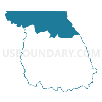
Outline

Summary
| Unique Area Identifier | 548281 |
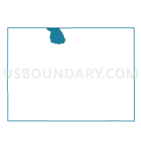
| Name | Jackson 2 |
| County | Jackson County |
| State | Colorado |
| Area (square miles) | 419.06 |
| Land Area (square miles) | 417.30 |
| Water Area (square miles) | 1.75 |
| % of Land Area | 99.58 |
| % of Water Area | 0.42 |
| Latitude of the Internal Point | 40.90488910 |
| Longtitude of the Internal Point | -106.41881670 |
Maps

Graphs
Select a template below for downloading or customizing gragh for Jackson 2, Jackson County, Colorado


Neighbors
Neighoring Voting District (by Name) Neighboring Voting District on the Map
- ENCAMPMENT Voting District, Carbon County, WY
- HARMONY SCHOOL Voting District, Albany County, WY
- Jackson 1, Jackson County, CO
- Jackson 5, Jackson County, CO
- Larimer 401, Larimer County, CO
- RIVERSIDE Voting District, Carbon County, WY
- Routt 1, Routt County, CO
Top 10 Neighboring County Subdivision (by Population) Neighboring County Subdivision on the Map
- Steamboat Springs CCD, Routt County, CO (16,818)
- Livermore CCD, Larimer County, CO (5,069)
- Saratoga CCD, Carbon County, WY (3,181)
- Hayden CCD, Routt County, CO (2,648)
- South Albany CCD, Albany County, WY (1,528)
- Walden CCD, Jackson County, CO (1,394)
Top 10 Neighboring Unified School District (by Population) Neighboring Unified School District on the Map
- Poudre School District R-1, CO (184,648)
- Albany County School District 1, WY (36,299)
- Steamboat Springs School District RE-2, CO (17,453)
- Carbon County School District 2, WY (4,796)
- North Park School District R-1, CO (1,394)
Top 10 Neighboring State Legislative District Lower Chamber (by Population) Neighboring State Legislative District Lower Chamber on the Map
- State House District 49, CO (83,740)
- State House District 57, CO (78,537)
- State House District 46, WY (9,230)
- State House District 47, WY (7,767)
Top 10 Neighboring State Legislative District Upper Chamber (by Population) Neighboring State Legislative District Upper Chamber on the Map
- State Senate District 15, CO (155,929)
- State Senate District 8, CO (148,629)
- State Senate District 10, WY (18,279)
- State Senate District 11, WY (16,180)
Top 10 Neighboring 111th Congressional District (by Population) Neighboring 111th Congressional District on the Map
- Congressional District 4, CO (725,041)
- Congressional District 3, CO (706,186)
- Congressional District (at Large), WY (563,626)
Top 10 Neighboring Census Tract (by Population) Neighboring Census Tract on the Map
- Census Tract 9680, Carbon County, WY (3,181)
- Census Tract 24.02, Larimer County, CO (2,963)
- Census Tract 1, Routt County, CO (2,151)
- Census Tract 9639, Albany County, WY (2,141)
- Census Tract 9556, Jackson County, CO (1,394)
Top 10 Neighboring 5-Digit ZIP Code Tabulation Area (by Population) Neighboring 5-Digit ZIP Code Tabulation Area on the Map
- 82070, WY (19,766)
- 80487, CO (16,745)
- 80480, CO (1,300)
- 82325, WY (878)
- 80428, CO (706)
- 82063, CO (100)
- 80434, CO (43)