


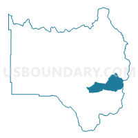
Grand 12, Grand County, Colorado
About
Outline

Summary
| Unique Area Identifier | 548243 |
| Name | Grand 12 |
| County | Grand County |
| State | Colorado |
| Area (square miles) | 67.74 |
| Land Area (square miles) | 67.56 |
| Water Area (square miles) | 0.18 |
| % of Land Area | 99.74 |
| % of Water Area | 0.26 |
| Latitude of the Internal Point | 39.96655260 |
| Longtitude of the Internal Point | -105.79883950 |
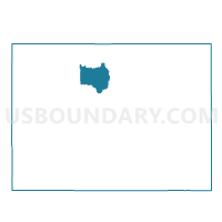
Maps

Graphs
Select a template below for downloading or customizing gragh for Grand 12, Grand County, Colorado


Neighbors
Neighoring Voting District (by Name) Neighboring Voting District on the Map
- Boulder 15, Boulder County, CO
- Grand 11, Grand County, CO
- Grand 2, Grand County, CO
- Grand 3, Grand County, CO
- Grand 7, Grand County, CO
- Grand 8, Grand County, CO
- Grand 9, Grand County, CO
Top 10 Neighboring County Subdivision (by Population) Neighboring County Subdivision on the Map
- Bald Mountain CCD, Boulder County, CO (12,286)
- Granby CCD, Grand County, CO (11,932)
- Kremmling CCD, Grand County, CO (2,911)
Top 10 Neighboring Place (by Population) Neighboring Place on the Map
Top 10 Neighboring Unified School District (by Population) Neighboring Unified School District on the Map
- Boulder Valley School District RE-2, CO (212,161)
- East Grand School District 2, CO (11,977)
- West Grand School District 1-JT, CO (3,046)
Top 10 Neighboring State Legislative District Lower Chamber (by Population) Neighboring State Legislative District Lower Chamber on the Map
Top 10 Neighboring State Legislative District Upper Chamber (by Population) Neighboring State Legislative District Upper Chamber on the Map
Top 10 Neighboring 111th Congressional District (by Population) Neighboring 111th Congressional District on the Map
Top 10 Neighboring Census Tract (by Population) Neighboring Census Tract on the Map
- Census Tract 2.02, Grand County, CO (7,115)
- Census Tract 137.02, Boulder County, CO (5,952)
- Census Tract 2.01, Grand County, CO (4,817)
- Census Tract 1, Grand County, CO (2,911)
Top 10 Neighboring 5-Digit ZIP Code Tabulation Area (by Population) Neighboring 5-Digit ZIP Code Tabulation Area on the Map
- 80446, CO (3,715)
- 80466, CO (3,338)
- 80442, CO (2,309)
- 80482, CO (1,630)
- 80478, CO (1,606)
- 80468, CO (391)