


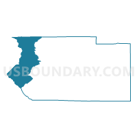
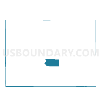
Fremont 24, Fremont County, Colorado
About
Outline

Summary
| Unique Area Identifier | 548182 |
| Name | Fremont 24 |
| County | Fremont County |
| State | Colorado |
| Area (square miles) | 187.59 |
| Land Area (square miles) | 187.55 |
| Water Area (square miles) | 0.04 |
| % of Land Area | 99.98 |
| % of Water Area | 0.02 |
| Latitude of the Internal Point | 38.57572120 |
| Longtitude of the Internal Point | -105.87260680 |
Maps

Graphs
Select a template below for downloading or customizing gragh for Fremont 24, Fremont County, Colorado


Neighbors
Neighoring Voting District (by Name) Neighboring Voting District on the Map
- Chaffee 14, Chaffee County, CO
- Chaffee 15, Chaffee County, CO
- Fremont 21, Fremont County, CO
- Fremont 22, Fremont County, CO
- Fremont 23, Fremont County, CO
- Park 7, Park County, CO
- Saguache 1, Saguache County, CO
Top 10 Neighboring County Subdivision (by Population) Neighboring County Subdivision on the Map
- Salida CCD, Chaffee County, CO (9,755)
- Cotopaxi CCD, Fremont County, CO (3,462)
- Saguache CCD, Saguache County, CO (3,009)
- Lake George CCD, Park County, CO (2,179)
Top 10 Neighboring Place (by Population) Neighboring Place on the Map
Top 10 Neighboring Unified School District (by Population) Neighboring Unified School District on the Map
- Salida School District R-32, CO (9,292)
- Park County School District RE-2, CO (6,962)
- Cotopaxi School District RE-3, CO (2,735)
- Mountain Valley School District RE-1, CO (1,366)
Top 10 Neighboring State Legislative District Lower Chamber (by Population) Neighboring State Legislative District Lower Chamber on the Map
Top 10 Neighboring State Legislative District Upper Chamber (by Population) Neighboring State Legislative District Upper Chamber on the Map
- State Senate District 4, CO (180,522)
- State Senate District 5, CO (128,103)
- State Senate District 2, CO (125,412)
Top 10 Neighboring 111th Congressional District (by Population) Neighboring 111th Congressional District on the Map
Top 10 Neighboring Census Tract (by Population) Neighboring Census Tract on the Map
- Census Tract 2, Chaffee County, CO (4,305)
- Census Tract 9790, Fremont County, CO (3,462)
- Census Tract 9776, Saguache County, CO (3,143)
- Census Tract 3, Chaffee County, CO (2,909)
- Census Tract 5, Park County, CO (2,179)
Top 10 Neighboring 5-Digit ZIP Code Tabulation Area (by Population) Neighboring 5-Digit ZIP Code Tabulation Area on the Map
- 81212, CO (29,742)
- 81201, CO (8,645)
- 81223, CO (1,639)
- 80449, CO (909)
- 81233, CO (823)
- 80820, CO (806)
- 81222, CO (263)
- 81155, CO (225)