


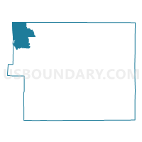
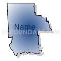
El Paso 265, El Paso County, Colorado
About
Outline

Summary
| Unique Area Identifier | 547837 |
| Name | El Paso 265 |
| County | El Paso County |
| State | Colorado |
| Area (square miles) | 75.41 |
| Land Area (square miles) | 74.71 |
| Water Area (square miles) | 0.69 |
| % of Land Area | 99.08 |
| % of Water Area | 0.92 |
| Latitude of the Internal Point | 39.04495210 |
| Longtitude of the Internal Point | -104.95171350 |
Maps


Graphs
Select a template below for downloading or customizing gragh for El Paso 265, El Paso County, Colorado


Neighbors
Neighoring Voting District (by Name) Neighboring Voting District on the Map
- Douglas 78, Douglas County, CO
- Douglas 81, Douglas County, CO
- El Paso 135, El Paso County, CO
- El Paso 136, El Paso County, CO
- El Paso 221, El Paso County, CO
- El Paso 336, El Paso County, CO
- El Paso 349, El Paso County, CO
- El Paso 71, El Paso County, CO
- El Paso 73, El Paso County, CO
- El Paso 76, El Paso County, CO
- Teller 8, Teller County, CO
Top 10 Neighboring County Subdivision (by Population) Neighboring County Subdivision on the Map
- Sedalia CCD, Douglas County, CO (141,391)
- Castle Rock CCD, Douglas County, CO (40,321)
- Divide CCD, Teller County, CO (20,071)
- Monument CCD, El Paso County, CO (19,923)
- Pikes Peak CCD, El Paso County, CO (3,703)
Top 10 Neighboring Place (by Population) Neighboring Place on the Map
Top 10 Neighboring Unified School District (by Population) Neighboring Unified School District on the Map
- Douglas County School District RE-1, CO (287,725)
- Academy School District 20, CO (97,718)
- Lewis-Palmer School District 38, CO (28,766)
- Woodland Park School District RE-2, CO (18,546)
- Manitou Springs School District 14, CO (8,224)
Top 10 Neighboring State Legislative District Lower Chamber (by Population) Neighboring State Legislative District Lower Chamber on the Map
- State House District 45, CO (110,234)
- State House District 20, CO (106,032)
- State House District 21, CO (66,065)
Top 10 Neighboring State Legislative District Upper Chamber (by Population) Neighboring State Legislative District Upper Chamber on the Map
- State Senate District 4, CO (180,522)
- State Senate District 9, CO (152,671)
- State Senate District 12, CO (143,518)
Top 10 Neighboring 111th Congressional District (by Population) Neighboring 111th Congressional District on the Map
Top 10 Neighboring Census Tract (by Population) Neighboring Census Tract on the Map
- Census Tract 37.01, El Paso County, CO (7,513)
- Census Tract 101.03, Teller County, CO (7,468)
- Census Tract 101.05, Teller County, CO (6,045)
- Census Tract 38.02, El Paso County, CO (4,486)
- Census Tract 34, El Paso County, CO (3,703)
- Census Tract 144.04, Douglas County, CO (2,323)
- Census Tract 38.01, El Paso County, CO (2,196)
- Census Tract 143, Douglas County, CO (730)
Top 10 Neighboring 5-Digit ZIP Code Tabulation Area (by Population) Neighboring 5-Digit ZIP Code Tabulation Area on the Map
- 80132, CO (19,637)
- 80921, CO (18,999)
- 80863, CO (11,754)
- 80840, CO (6,682)
- 80118, CO (5,308)
- 80135, CO (3,833)
- 80133, CO (2,042)
- 80819, CO (921)