


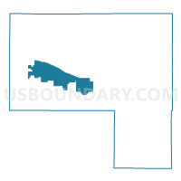
Elbert 13, Elbert County, Colorado
About
Outline

Summary
| Unique Area Identifier | 547759 |
| Name | Elbert 13 |
| County | Elbert County |
| State | Colorado |
| Area (square miles) | 83.52 |
| Land Area (square miles) | 83.52 |
| Water Area (square miles) | 0.00 |
| % of Land Area | 100.00 |
| % of Water Area | 0.00 |
| Latitude of the Internal Point | 39.27996930 |
| Longtitude of the Internal Point | -104.37135930 |
Maps


Graphs
Select a template below for downloading or customizing gragh for Elbert 13, Elbert County, Colorado


Neighbors
Neighoring Voting District (by Name) Neighboring Voting District on the Map
- Elbert 10, Elbert County, CO
- Elbert 11, Elbert County, CO
- Elbert 18, Elbert County, CO
- Elbert 3, Elbert County, CO
- Elbert 4, Elbert County, CO
- Elbert 5, Elbert County, CO
Top 10 Neighboring County Subdivision (by Population) Neighboring County Subdivision on the Map
- Elizabeth CCD, Elbert County, CO (21,076)
- Simla CCD, Elbert County, CO (1,481)
- Agate CCD, Elbert County, CO (529)
Top 10 Neighboring Place (by Population) Neighboring Place on the Map
Top 10 Neighboring Unified School District (by Population) Neighboring Unified School District on the Map
- Elizabeth School District C-1, CO (14,249)
- Calhan School District RJ-1, CO (2,997)
- Kiowa School District C-2, CO (2,595)
- Big Sandy School District 100J, CO (1,845)
- Elbert School District 200, CO (1,554)
Top 10 Neighboring State Legislative District Lower Chamber (by Population) Neighboring State Legislative District Lower Chamber on the Map
Top 10 Neighboring State Legislative District Upper Chamber (by Population) Neighboring State Legislative District Upper Chamber on the Map
Top 10 Neighboring 111th Congressional District (by Population) Neighboring 111th Congressional District on the Map
Top 10 Neighboring Census Tract (by Population) Neighboring Census Tract on the Map
- Census Tract 9612.07, Elbert County, CO (3,711)
- Census Tract 9612.08, Elbert County, CO (3,208)
- Census Tract 9612.09, Elbert County, CO (2,351)
- Census Tract 9611, Elbert County, CO (2,010)
- Census Tract 9612.05, Elbert County, CO (1,707)
Top 10 Neighboring 5-Digit ZIP Code Tabulation Area (by Population) Neighboring 5-Digit ZIP Code Tabulation Area on the Map
- 80107, CO (12,042)
- 80808, CO (6,351)
- 80106, CO (4,232)
- 80117, CO (2,587)
- 80835, CO (911)
- 80832, CO (666)