


Conejos 10, Conejos County, Colorado
About
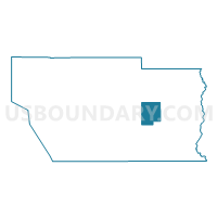
Outline

Summary
| Unique Area Identifier | 547108 |
| Name | Conejos 10 |
| County | Conejos County |
| State | Colorado |
| Area (square miles) | 28.47 |
| Land Area (square miles) | 28.45 |
| Water Area (square miles) | 0.02 |
| % of Land Area | 99.95 |
| % of Water Area | 0.05 |
| Latitude of the Internal Point | 37.18908880 |
| Longtitude of the Internal Point | -105.99234820 |
Maps

Graphs
Select a template below for downloading or customizing gragh for Conejos 10, Conejos County, Colorado


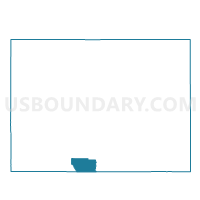
Neighbors
Neighoring Voting District (by Name) Neighboring Voting District on the Map
- Conejos 1, Conejos County, CO
- Conejos 2, Conejos County, CO
- Conejos 5, Conejos County, CO
- Conejos 6, Conejos County, CO
- Conejos 9, Conejos County, CO
Top 10 Neighboring County Subdivision (by Population) Neighboring County Subdivision on the Map
- La Jara CCD, Conejos County, CO (3,667)
- Manassa CCD, Conejos County, CO (2,120)
- Antonito CCD, Conejos County, CO (1,767)
- West Conejos CCD, Conejos County, CO (702)