


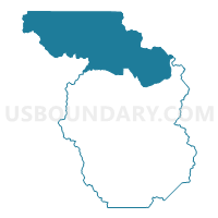
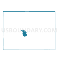
Chaffee 6, Chaffee County, Colorado
About
Outline

Summary
| Unique Area Identifier | 547076 |
| Name | Chaffee 6 |
| County | Chaffee County |
| State | Colorado |
| Area (square miles) | 305.47 |
| Land Area (square miles) | 304.68 |
| Water Area (square miles) | 0.78 |
| % of Land Area | 99.74 |
| % of Water Area | 0.26 |
| Latitude of the Internal Point | 38.97341460 |
| Longtitude of the Internal Point | -106.38173670 |
Maps

Graphs
Select a template below for downloading or customizing gragh for Chaffee 6, Chaffee County, Colorado


Neighbors
Neighoring Voting District (by Name) Neighboring Voting District on the Map
- Chaffee 10, Chaffee County, CO
- Chaffee 13, Chaffee County, CO
- Chaffee 7, Chaffee County, CO
- Chaffee 8, Chaffee County, CO
- Gunnison 6, Gunnison County, CO
- Lake 2, Lake County, CO
- Lake 5, Lake County, CO
- Park 7, Park County, CO
- Pitkin 1, Pitkin County, CO
Top 10 Neighboring County Subdivision (by Population) Neighboring County Subdivision on the Map
- Fairplay CCD, Park County, CO (14,027)
- Gunnison CCD, Gunnison County, CO (9,918)
- Aspen CCD, Pitkin County, CO (9,467)
- Buena Vista CCD, Chaffee County, CO (8,054)
- Leadville CCD, Lake County, CO (6,089)
- Lake George CCD, Park County, CO (2,179)
Top 10 Neighboring Place (by Population) Neighboring Place on the Map
Top 10 Neighboring Unified School District (by Population) Neighboring Unified School District on the Map
- Gunnison Watershed School District RE-1J, CO (15,260)
- Aspen School District 1, CO (13,015)
- Buena Vista School District R-31, CO (8,659)
- Lake County School District R-1, CO (7,310)
- Park County School District RE-2, CO (6,962)
Top 10 Neighboring State Legislative District Lower Chamber (by Population) Neighboring State Legislative District Lower Chamber on the Map
- State House District 61, CO (79,637)
- State House District 56, CO (79,238)
- State House District 60, CO (72,008)
Top 10 Neighboring State Legislative District Upper Chamber (by Population) Neighboring State Legislative District Upper Chamber on the Map
Top 10 Neighboring 111th Congressional District (by Population) Neighboring 111th Congressional District on the Map
Top 10 Neighboring Census Tract (by Population) Neighboring Census Tract on the Map
- Census Tract 4.01, Chaffee County, CO (4,531)
- Census Tract 9636, Gunnison County, CO (3,794)
- Census Tract 4.02, Chaffee County, CO (3,523)
- Census Tract 5, Pitkin County, CO (2,433)
- Census Tract 5, Park County, CO (2,179)
- Census Tract 9619, Lake County, CO (2,170)
- Census Tract 4, Park County, CO (2,099)
Top 10 Neighboring 5-Digit ZIP Code Tabulation Area (by Population) Neighboring 5-Digit ZIP Code Tabulation Area on the Map
- 81611, CO (9,921)
- 81211, CO (7,623)
- 80461, CO (7,090)
- 80449, CO (909)
- 81210, CO (275)
- 81251, CO (220)