


Boulder 66, Boulder County, Colorado
About
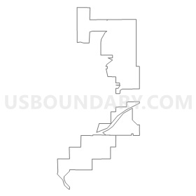
Outline
Summary
| Unique Area Identifier | 546839 |
| Name | Boulder 66 |
| County | Boulder County |
| State | Colorado |
| Area (square miles) | 8.84 |
| Land Area (square miles) | 8.66 |
| Water Area (square miles) | 0.18 |
| % of Land Area | 97.99 |
| % of Water Area | 2.01 |
| Latitude of the Internal Point | 40.00875520 |
| Longtitude of the Internal Point | -105.06648160 |
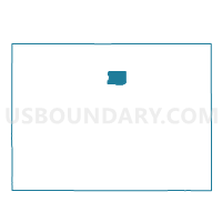
Maps

Graphs
Select a template below for downloading or customizing gragh for Boulder 66, Boulder County, Colorado


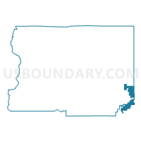
Neighbors
Neighoring Voting District (by Name) Neighboring Voting District on the Map
- Boulder 30, Boulder County, CO
- Boulder 31, Boulder County, CO
- Boulder 33, Boulder County, CO
- Boulder 34, Boulder County, CO
- Boulder 35, Boulder County, CO
- Boulder 43, Boulder County, CO
- Boulder 45, Boulder County, CO
- Boulder 51, Boulder County, CO
- Boulder 61, Boulder County, CO
- Boulder 64, Boulder County, CO
- Boulder 67, Boulder County, CO
- Boulder 68, Boulder County, CO
- Broomfield 10, Broomfield County, CO
- Broomfield 12, Broomfield County, CO
- Broomfield 17, Broomfield County, CO
- Broomfield 2, Broomfield County, CO
- Broomfield 25, Broomfield County, CO
- Broomfield 26, Broomfield County, CO
- Broomfield 3, Broomfield County, CO
- Broomfield 35, Broomfield County, CO
- Broomfield 4, Broomfield County, CO
- Broomfield 5, Broomfield County, CO
- Weld 306, Weld County, CO
Top 10 Neighboring County Subdivision (by Population) Neighboring County Subdivision on the Map
- Lafayette-Louisville CCD, Boulder County, CO (65,784)
- Broomfield CCD, Broomfield County, CO (55,889)
- Erie-Frederick CCD, Weld County, CO (37,786)
Top 10 Neighboring Place (by Population) Neighboring Place on the Map
Top 10 Neighboring Unified School District (by Population) Neighboring Unified School District on the Map
- Boulder Valley School District RE-2, CO (212,161)
- Northglenn-Thornton School District 12, CO (209,792)
- St. Vrain Valley School District RE 1J, CO (151,981)
Top 10 Neighboring State Legislative District Lower Chamber (by Population) Neighboring State Legislative District Lower Chamber on the Map
- State House District 48, CO (112,104)
- State House District 33, CO (94,061)
- State House District 12, CO (69,766)
Top 10 Neighboring State Legislative District Upper Chamber (by Population) Neighboring State Legislative District Upper Chamber on the Map
Top 10 Neighboring 111th Congressional District (by Population) Neighboring 111th Congressional District on the Map
Top 10 Neighboring Census Tract (by Population) Neighboring Census Tract on the Map
- Census Tract 128, Boulder County, CO (10,822)
- Census Tract 608, Boulder County, CO (6,107)
- Census Tract 309, Broomfield County, CO (5,938)
- Census Tract 305, Broomfield County, CO (5,911)
- Census Tract 20.07, Weld County, CO (5,110)
- Census Tract 609, Boulder County, CO (4,139)
- Census Tract 312, Broomfield County, CO (3,059)
- Census Tract 129.07, Boulder County, CO (2,922)
- Census Tract 314, Broomfield County, CO (2,583)
- Census Tract 129.03, Boulder County, CO (2,195)