


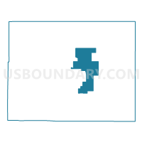
Baca 5, Baca County, Colorado
About
Outline

Summary
| Unique Area Identifier | 546791 |
| Name | Baca 5 |
| County | Baca County |
| State | Colorado |
| Area (square miles) | 133.37 |
| Land Area (square miles) | 133.37 |
| Water Area (square miles) | 0.00 |
| % of Land Area | 100.00 |
| % of Water Area | 0.00 |
| Latitude of the Internal Point | 37.34364530 |
| Longtitude of the Internal Point | -102.43992560 |
Maps


Graphs
Select a template below for downloading or customizing gragh for Baca 5, Baca County, Colorado


Neighbors
Neighoring Voting District (by Name) Neighboring Voting District on the Map
- Baca 2, Baca County, CO
- Baca 4, Baca County, CO
- Baca 6, Baca County, CO
- Baca 8, Baca County, CO
- Baca 9, Baca County, CO
Top 10 Neighboring County Subdivision (by Population) Neighboring County Subdivision on the Map
- Springfield CCD, Baca County, CO (2,050)
- Walsh CCD, Baca County, CO (1,100)
- Campo CCD, Baca County, CO (328)
Top 10 Neighboring Place (by Population) Neighboring Place on the Map
Top 10 Neighboring Unified School District (by Population) Neighboring Unified School District on the Map
- Springfield School District RE-4, CO (1,998)
- Walsh School District RE-1, CO (994)
- Campo School District RE-6, CO (254)
- Vilas School District RE-5, CO (239)