


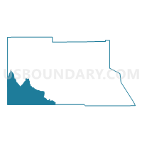
Archuleta 4, Archuleta County, Colorado
About
Outline

Summary
| Unique Area Identifier | 546779 |
| Name | Archuleta 4 |
| County | Archuleta County |
| State | Colorado |
| Area (square miles) | 153.78 |
| Land Area (square miles) | 149.58 |
| Water Area (square miles) | 4.21 |
| % of Land Area | 97.27 |
| % of Water Area | 2.73 |
| Latitude of the Internal Point | 37.05513230 |
| Longtitude of the Internal Point | -107.36631670 |
Maps

Graphs
Select a template below for downloading or customizing gragh for Archuleta 4, Archuleta County, Colorado


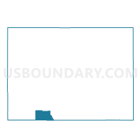
Neighbors
Neighoring Voting District (by Name) Neighboring Voting District on the Map
- Archuleta 5, Archuleta County, CO
- Archuleta 8, Archuleta County, CO
- La Plata 25, La Plata County, CO
- Rio Arriba County Precinct 24, Rio Arriba County, NM
- San Juan County Precinct 72, San Juan County, NM
Top 10 Neighboring County Subdivision (by Population) Neighboring County Subdivision on the Map
- Bloomfield CCD, San Juan County, NM (17,790)
- Pagosa Springs CCD, Archuleta County, CO (11,223)
- Ignacio CCD, La Plata County, CO (5,575)
- Jicarilla Apache CCD, Rio Arriba County, NM (3,228)
- Arboles CCD, Archuleta County, CO (861)
- West Rio Arriba CCD, Rio Arriba County, NM (271)
Top 10 Neighboring Place (by Population) Neighboring Place on the Map
Top 10 Neighboring Unified School District (by Population) Neighboring Unified School District on the Map
- Aztec Municipal Schools, NM (16,755)
- Archuleta County School District 50-JT, CO (11,526)
- Ignacio School District 11-JT, CO (5,485)
- Dulce Independent Schools, NM (3,460)
Top 10 Neighboring State Legislative District Lower Chamber (by Population) Neighboring State Legislative District Lower Chamber on the Map
- State House District 59, CO (78,431)
- State House District 3, NM (31,169)
- State House District 65, NM (26,930)
Top 10 Neighboring State Legislative District Upper Chamber (by Population) Neighboring State Legislative District Upper Chamber on the Map
- State Senate District 6, CO (144,787)
- State Senate District 22, NM (60,988)
- State Senate District 2, NM (53,101)
Top 10 Neighboring 111th Congressional District (by Population) Neighboring 111th Congressional District on the Map
Top 10 Neighboring Census Tract (by Population) Neighboring Census Tract on the Map
- Census Tract 9403, La Plata County, CO (5,575)
- Census Tract 9410, Rio Arriba County, NM (3,499)
- Census Tract 7.06, San Juan County, NM (3,252)
- Census Tract 9404, Archuleta County, CO (1,188)
Top 10 Neighboring 5-Digit ZIP Code Tabulation Area (by Population) Neighboring 5-Digit ZIP Code Tabulation Area on the Map
- 81147, CO (11,446)
- 81122, CO (8,228)
- 81137, CO (5,225)
- 87528, NM (3,417)
- 87419, NM (464)
- 81121, CO (270)