


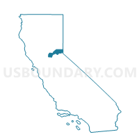
Voting District 50505, Placer County, California
About
Outline

Summary
| Unique Area Identifier | 536701 |
| Name | Voting District 50505 |
| County | Placer County |
| State | California |
| Area (square miles) | 133.33 |
| Land Area (square miles) | 54.38 |
| Water Area (square miles) | 78.95 |
| % of Land Area | 40.79 |
| % of Water Area | 59.21 |
| Latitude of the Internal Point | 39.18527570 |
| Longtitude of the Internal Point | -120.09614420 |
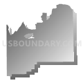
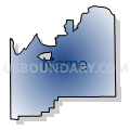
Maps


Graphs
Select a template below for downloading or customizing gragh for Voting District 50505, Placer County, California


Neighbors
Neighoring Voting District (by Name) Neighboring Voting District on the Map
- Voting District 40285, El Dorado County, CA
- Voting District 50005, Placer County, CA
- Voting District 50425, El Dorado County, CA
- Voting District 50430, El Dorado County, CA
- Voting District 50500, Placer County, CA
- Voting District 50525, Placer County, CA
- Voting District 50620, Placer County, CA
- Voting District 50630, Placer County, CA
- Voting District 50640, Placer County, CA
- Voting District 50650, Placer County, CA
- Voting District 50655, Placer County, CA
- Voting District 50830, Placer County, CA
- Voting District 50835, Placer County, CA
- Voting District 50840, Placer County, CA
- Precinct 105, Carson City, NV
- Precinct No. 8110, Washoe County, NV
- Voting Districts not defined, Douglas County, NV
- Voting Districts not defined, Washoe County, NV
Top 10 Neighboring County Subdivision (by Population) Neighboring County Subdivision on the Map
- Carson City CCD, Carson City, NV (55,274)
- North El Dorado CCD, El Dorado County, CA (31,207)
- South Lake Tahoe CCD, El Dorado County, CA (30,728)
- Colfax-Monumental Ridge CCD, Placer County, CA (20,351)
- Lake Tahoe CCD, Placer County, CA (10,448)
- Incline Village CCD, Washoe County, NV (9,087)
- Foresthill-Back Country CCD, Placer County, CA (6,146)
- Zephyr Cove CCD, Douglas County, NV (5,402)
Top 10 Neighboring Place (by Population) Neighboring Place on the Map
- Carson City, NV (55,274)
- Kings Beach CDP, CA (3,796)
- Sunnyside-Tahoe City CDP, CA (1,557)
- Tahoe Vista CDP, CA (1,433)
- Dollar Point CDP, CA (1,215)
- Tahoma CDP, CA (1,191)
- Carnelian Bay CDP, CA (524)
- Crystal Bay CDP, NV (305)
Top 10 Neighboring Elementary School District (by Population) Neighboring Elementary School District on the Map
Top 10 Neighboring Secondary School District (by Population) Neighboring Secondary School District on the Map
Top 10 Neighboring Unified School District (by Population) Neighboring Unified School District on the Map
- Washoe County School District, NV (421,407)
- Carson City School District, NV (55,274)
- Douglas County School District, NV (46,997)
- Tahoe-Truckee Joint Unified School District, CA (31,699)
- Lake Tahoe Unified School District, CA (29,839)
- Black Oak Mine Unified School District, CA (13,572)
Top 10 Neighboring State Legislative District Lower Chamber (by Population) Neighboring State Legislative District Lower Chamber on the Map
Top 10 Neighboring State Legislative District Upper Chamber (by Population) Neighboring State Legislative District Upper Chamber on the Map
- State Senate District 1, CA (1,002,597)
- Washoe County Senatorial District 4, NV (110,453)
- Capital Senatorial District, NV (102,155)
Top 10 Neighboring 111th Congressional District (by Population) Neighboring 111th Congressional District on the Map
Top 10 Neighboring Census Tract (by Population) Neighboring Census Tract on the Map
- Census Tract 202, Placer County, CA (6,146)
- Census Tract 306.03, El Dorado County, CA (3,566)
- Census Tract 201.07, Placer County, CA (3,510)
- Census Tract 33.08, Washoe County, NV (2,333)
- Census Tract 220.14, Placer County, CA (1,736)
- Census Tract 201.06, Placer County, CA (1,719)
- Census Tract 220.11, Placer County, CA (1,686)
- Census Tract 201.05, Placer County, CA (1,352)
- Census Tract 201.04, Placer County, CA (1,288)
- Census Tract 320, El Dorado County, CA (1,015)
Top 10 Neighboring 5-Digit ZIP Code Tabulation Area (by Population) Neighboring 5-Digit ZIP Code Tabulation Area on the Map
- 96143, CA (4,414)
- 96145, CA (3,161)
- 96146, CA (1,366)
- 96140, CA (1,170)
- 96142, CA (1,037)
- 96148, CA (788)
- 96141, CA (744)
- 89402, NV (71)