


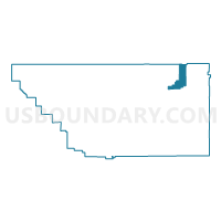
Voting District 10015, Kern County, California
About
Outline

Summary
| Unique Area Identifier | 532014 |
| Name | Voting District 10015 |
| County | Kern County |
| State | California |
| Area (square miles) | 103.08 |
| Land Area (square miles) | 103.08 |
| Water Area (square miles) | 0.00 |
| % of Land Area | 100.00 |
| % of Water Area | 0.00 |
| Latitude of the Internal Point | 35.62405970 |
| Longtitude of the Internal Point | -117.98693800 |
Maps


Graphs
Select a template below for downloading or customizing gragh for Voting District 10015, Kern County, California


Neighbors
Neighoring Voting District (by Name) Neighboring Voting District on the Map
- Voting District 10010, Kern County, CA
- Voting District 10020, Kern County, CA
- Voting District 10055, Kern County, CA
- Voting District 10655, Kern County, CA
- Voting District 50120, Inyo County, CA
- Voting District 55450, Tulare County, CA
Top 10 Neighboring County Subdivision (by Population) Neighboring County Subdivision on the Map
- East Kern CCD, Kern County, CA (78,648)
- Lake Isabella CCD, Kern County, CA (16,234)
- Springville-Johnsondale CCD, Tulare County, CA (5,615)
- Lone Pine CCD, Inyo County, CA (2,613)
Top 10 Neighboring Elementary School District (by Population) Neighboring Elementary School District on the Map
- South Fork Union Elementary School District, CA (3,680)
- Hot Springs Elementary School District, CA (317)
Top 10 Neighboring Secondary School District (by Population) Neighboring Secondary School District on the Map
- Kern Union High School District, CA (596,351)
- Porterville Unified (9-12) School District, CA (47,072)
Top 10 Neighboring Unified School District (by Population) Neighboring Unified School District on the Map
Top 10 Neighboring State Legislative District Lower Chamber (by Population) Neighboring State Legislative District Lower Chamber on the Map
Top 10 Neighboring State Legislative District Upper Chamber (by Population) Neighboring State Legislative District Upper Chamber on the Map
Top 10 Neighboring 111th Congressional District (by Population) Neighboring 111th Congressional District on the Map
- Congressional District 25, CA (844,320)
- Congressional District 22, CA (797,084)
- Congressional District 21, CA (784,176)
Top 10 Neighboring Census Tract (by Population) Neighboring Census Tract on the Map
- Census Tract 55.01, Kern County, CA (6,275)
- Census Tract 27, Tulare County, CA (5,615)
- Census Tract 52.01, Kern County, CA (5,397)
- Census Tract 52.03, Kern County, CA (4,679)
- Census Tract 8, Inyo County, CA (3,378)