


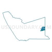
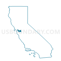
Voting District 10135, Alameda County, California
About
Outline

Summary
| Unique Area Identifier | 528878 |
| Name | Voting District 10135 |
| County | Alameda County |
| State | California |
| Area (square miles) | 15.16 |
| Land Area (square miles) | 15.16 |
| Water Area (square miles) | 0.00 |
| % of Land Area | 100.00 |
| % of Water Area | 0.00 |
| Latitude of the Internal Point | 37.63938110 |
| Longtitude of the Internal Point | -121.59433680 |
Maps

Graphs
Select a template below for downloading or customizing gragh for Voting District 10135, Alameda County, California


Neighbors
Neighoring Voting District (by Name) Neighboring Voting District on the Map
- Voting District 10125, Alameda County, CA
- Voting District 10130, Alameda County, CA
- Voting District 10205, Alameda County, CA
- Voting District 51755, San Joaquin County, CA
Top 10 Neighboring County Subdivision (by Population) Neighboring County Subdivision on the Map
Top 10 Neighboring Elementary School District (by Population) Neighboring Elementary School District on the Map
- Jefferson Elementary School District, CA (14,519)
- Mountain House Elementary School District, CA (345)
Top 10 Neighboring Unified School District (by Population) Neighboring Unified School District on the Map
Top 10 Neighboring State Legislative District Lower Chamber (by Population) Neighboring State Legislative District Lower Chamber on the Map
Top 10 Neighboring State Legislative District Upper Chamber (by Population) Neighboring State Legislative District Upper Chamber on the Map
- State Senate District 14, CA (1,020,927)
- State Senate District 10, CA (893,839)
- State Senate District 9, CA (878,605)