


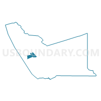
Voting District 20620, Alameda County, California
About
Outline

Summary
| Unique Area Identifier | 528862 |
| Name | Voting District 20620 |
| County | Alameda County |
| State | California |
| Area (square miles) | 7.19 |
| Land Area (square miles) | 7.19 |
| Water Area (square miles) | 0.00 |
| % of Land Area | 100.00 |
| % of Water Area | 0.00 |
| Latitude of the Internal Point | 37.64125590 |
| Longtitude of the Internal Point | -122.11165960 |
Maps

Graphs
Select a template below for downloading or customizing gragh for Voting District 20620, Alameda County, California


Neighbors
Neighoring Voting District (by Name) Neighboring Voting District on the Map
- Voting District 20565, Alameda County, CA
- Voting District 20570, Alameda County, CA
- Voting District 20585, Alameda County, CA
- Voting District 20590, Alameda County, CA
- Voting District 20605, Alameda County, CA
- Voting District 20610, Alameda County, CA
- Voting District 20615, Alameda County, CA
- Voting District 20625, Alameda County, CA
- Voting District 20630, Alameda County, CA
- Voting District 20635, Alameda County, CA
- Voting District 20650, Alameda County, CA
- Voting District 20690, Alameda County, CA
- Voting District 20695, Alameda County, CA
- Voting District 20700, Alameda County, CA
- Voting District 20760, Alameda County, CA
- Voting District 20765, Alameda County, CA
- Voting District 30930, Alameda County, CA
- Voting District 41370, Alameda County, CA
- Voting District BAY, Alameda County, CA
Top 10 Neighboring County Subdivision (by Population) Neighboring County Subdivision on the Map
Top 10 Neighboring Place (by Population) Neighboring Place on the Map
Top 10 Neighboring Unified School District (by Population) Neighboring Unified School District on the Map
Top 10 Neighboring State Legislative District Lower Chamber (by Population) Neighboring State Legislative District Lower Chamber on the Map
Top 10 Neighboring State Legislative District Upper Chamber (by Population) Neighboring State Legislative District Upper Chamber on the Map
Top 10 Neighboring 111th Congressional District (by Population) Neighboring 111th Congressional District on the Map
Top 10 Neighboring Census Tract (by Population) Neighboring Census Tract on the Map
- Census Tract 4363, Alameda County, CA (7,129)
- Census Tract 4372, Alameda County, CA (6,755)
- Census Tract 4369, Alameda County, CA (6,724)
- Census Tract 4371.01, Alameda County, CA (6,448)
- Census Tract 4382.04, Alameda County, CA (5,368)
- Census Tract 4356.01, Alameda County, CA (4,902)
- Census Tract 4378, Alameda County, CA (4,621)
- Census Tract 4357, Alameda County, CA (4,594)
- Census Tract 4366.02, Alameda County, CA (4,571)
- Census Tract 4382.01, Alameda County, CA (4,540)