


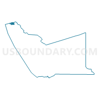
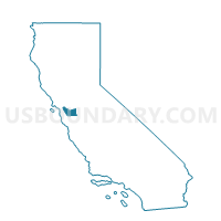
Voting District 51595, Alameda County, California
About
Outline

Summary
| Unique Area Identifier | 528735 |
| Name | Voting District 51595 |
| County | Alameda County |
| State | California |
| Area (square miles) | 1.79 |
| Land Area (square miles) | 1.79 |
| Water Area (square miles) | 0.00 |
| % of Land Area | 100.00 |
| % of Water Area | 0.00 |
| Latitude of the Internal Point | 37.88885960 |
| Longtitude of the Internal Point | -122.29996420 |
Maps

Graphs
Select a template below for downloading or customizing gragh for Voting District 51595, Alameda County, California


Neighbors
Neighoring Voting District (by Name) Neighboring Voting District on the Map
- Voting District 10090, Contra Costa County, CA
- Voting District 10250, Contra Costa County, CA
- Voting District 10285, Contra Costa County, CA
- Voting District 10325, Contra Costa County, CA
- Voting District 10410, Contra Costa County, CA
- Voting District 51600, Alameda County, CA
- Voting District 51605, Alameda County, CA
- Voting District 51650, Alameda County, CA
- Voting District 51655, Alameda County, CA
- Voting District BAY, Alameda County, CA
Top 10 Neighboring County Subdivision (by Population) Neighboring County Subdivision on the Map
Top 10 Neighboring Place (by Population) Neighboring Place on the Map
- Berkeley city, CA (112,580)
- Richmond city, CA (103,701)
- El Cerrito city, CA (23,549)
- Albany city, CA (18,539)
- Kensington CDP, CA (5,077)
Top 10 Neighboring Unified School District (by Population) Neighboring Unified School District on the Map
- West Contra Costa Unified School District, CA (235,847)
- Berkeley Unified School District, CA (112,517)
- Albany City Unified School District, CA (18,549)
Top 10 Neighboring State Legislative District Lower Chamber (by Population) Neighboring State Legislative District Lower Chamber on the Map
Top 10 Neighboring State Legislative District Upper Chamber (by Population) Neighboring State Legislative District Upper Chamber on the Map
Top 10 Neighboring 111th Congressional District (by Population) Neighboring 111th Congressional District on the Map
- Congressional District 10, CA (714,750)
- Congressional District 7, CA (655,708)
- Congressional District 9, CA (648,766)
Top 10 Neighboring Census Tract (by Population) Neighboring Census Tract on the Map
- Census Tract 3820, Contra Costa County, CA (6,964)
- Census Tract 3800, Contra Costa County, CA (5,706)
- Census Tract 4203, Alameda County, CA (4,571)
- Census Tract 3830, Contra Costa County, CA (4,485)
- Census Tract 4213, Alameda County, CA (3,844)
- Census Tract 4219, Alameda County, CA (3,632)
- Census Tract 4206, Alameda County, CA (3,283)
- Census Tract 4204, Alameda County, CA (3,124)
- Census Tract 4202, Alameda County, CA (2,898)
- Census Tract 3910, Contra Costa County, CA (2,556)