


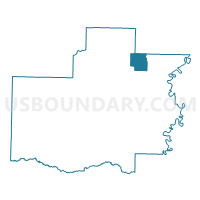
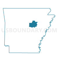
Velvet Ridge Voting District, White County, Arkansas
About
Outline

Summary
| Unique Area Identifier | 528477 |
| Name | Velvet Ridge Voting District |
| County | White County |
| State | Arkansas |
| Area (square miles) | 14.58 |
| Land Area (square miles) | 14.58 |
| Water Area (square miles) | 0.00 |
| % of Land Area | 100.00 |
| % of Water Area | 0.00 |
| Latitude of the Internal Point | 35.41380950 |
| Longtitude of the Internal Point | -91.56679140 |
Maps

Graphs
Select a template below for downloading or customizing gragh for Velvet Ridge Voting District, White County, Arkansas


Neighbors
Neighoring Voting District (by Name) Neighboring Voting District on the Map
- Bald Knob North Voting District, White County, AR
- Coldwell Voting District, White County, AR
- Crossroads Voting District, Jackson County, AR
- Denmark Voting District, Jackson County, AR
- Denmark Voting District, White County, AR
- Liberty Voting District, White County, AR
- Russell TWP Voting District, White County, AR
Top 10 Neighboring County Subdivision (by Population) Neighboring County Subdivision on the Map
- Bald Knob township, White County, AR (4,193)
- Liberty township, White County, AR (1,514)
- Velvet Ridge township, White County, AR (922)
- Barren township, Jackson County, AR (910)
- Coldwell township, White County, AR (584)
- Denmark township, White County, AR (532)
- Russell township, White County, AR (500)