


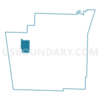
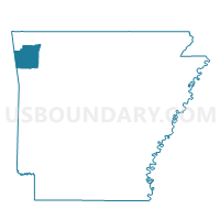
RHEAS MILL Voting District, Washington County, Arkansas
About
Outline

Summary
| Unique Area Identifier | 528408 |
| Name | RHEAS MILL Voting District |
| County | Washington County |
| State | Arkansas |
| Area (square miles) | 16.39 |
| Land Area (square miles) | 16.18 |
| Water Area (square miles) | 0.21 |
| % of Land Area | 98.71 |
| % of Water Area | 1.29 |
| Latitude of the Internal Point | 36.01658470 |
| Longtitude of the Internal Point | -94.40184550 |
Maps

Graphs
Select a template below for downloading or customizing gragh for RHEAS MILL Voting District, Washington County, Arkansas


Neighbors
Neighoring Voting District (by Name) Neighboring Voting District on the Map
- ILLINOIS Voting District, Washington County, AR
- MARS HILL Voting District, Washington County, AR
- PRAIRIE GROVE Voting District, Washington County, AR
- STARR HILL Voting District, Washington County, AR
- WEDINGTON Voting District, Washington County, AR
Top 10 Neighboring County Subdivision (by Population) Neighboring County Subdivision on the Map
- Prairie Grove township, Washington County, AR (5,904)
- Starr Hill township, Washington County, AR (1,847)
- Marrs Hill township, Washington County, AR (1,003)
- Illinois township, Washington County, AR (853)
- Rheas Mill township, Washington County, AR (569)
- Wedington township, Washington County, AR (471)
Top 10 Neighboring Unified School District (by Population) Neighboring Unified School District on the Map
- Siloam Springs Schools, AR (21,753)
- Prairie Grove School District, AR (9,100)
- Lincoln School District, AR (7,060)