


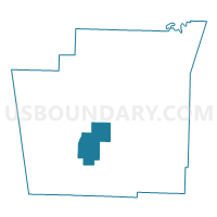
VALLEY Voting District, Washington County, Arkansas
About
Outline

Summary
| Unique Area Identifier | 528390 |
| Name | VALLEY Voting District |
| County | Washington County |
| State | Arkansas |
| Area (square miles) | 30.94 |
| Land Area (square miles) | 30.78 |
| Water Area (square miles) | 0.16 |
| % of Land Area | 99.49 |
| % of Water Area | 0.51 |
| Latitude of the Internal Point | 35.90069090 |
| Longtitude of the Internal Point | -94.26595150 |
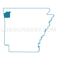
Maps

Graphs
Select a template below for downloading or customizing gragh for VALLEY Voting District, Washington County, Arkansas


Neighbors
Neighoring Voting District (by Name) Neighboring Voting District on the Map
- CANE HILL Voting District, Washington County, AR
- COVE CREEK Voting District, Washington County, AR
- GREENLAND Voting District, Washington County, AR
- PRAIRIE GROVE Voting District, Washington County, AR
- PRAIRIE GROVE SENATE Voting District, Washington County, AR
- WEST FORK Voting District, Washington County, AR
Top 10 Neighboring County Subdivision (by Population) Neighboring County Subdivision on the Map
- Prairie Grove township, Washington County, AR (5,904)
- West Fork township, Washington County, AR (3,651)
- Cane Hill township, Washington County, AR (1,530)
- Valley township, Washington County, AR (1,322)
- Cove Creek township, Washington County, AR (715)
Top 10 Neighboring Unified School District (by Population) Neighboring Unified School District on the Map
- Prairie Grove School District, AR (9,100)
- Greenland Public Schools, AR (6,325)
- West Fork School District, AR (5,446)
Top 10 Neighboring State Legislative District Lower Chamber (by Population) Neighboring State Legislative District Lower Chamber on the Map
Top 10 Neighboring State Legislative District Upper Chamber (by Population) Neighboring State Legislative District Upper Chamber on the Map
- State Senate District 35, AR (102,238)
- State Senate District 7, AR (93,757)
- State Senate District 3, AR (87,143)
Top 10 Neighboring 111th Congressional District (by Population) Neighboring 111th Congressional District on the Map
Top 10 Neighboring Census Tract (by Population) Neighboring Census Tract on the Map
- Census Tract 110.01, Washington County, AR (7,984)
- Census Tract 110.03, Washington County, AR (4,927)
- Census Tract 110.02, Washington County, AR (4,666)
- Census Tract 110.04, Washington County, AR (3,803)