


FAYETTEVILLE PCT 39, Washington County, Arkansas
About
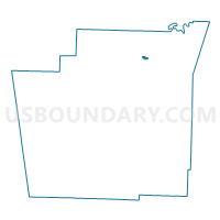
Outline

Summary
| Unique Area Identifier | 528363 |
| Name | FAYETTEVILLE PCT 39 |
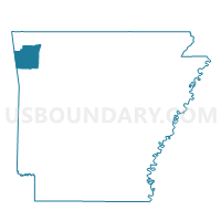
| County | Washington County |
| State | Arkansas |
| Area (square miles) | 0.25 |
| Land Area (square miles) | 0.25 |
| Water Area (square miles) | 0.00 |
| % of Land Area | 99.08 |
| % of Water Area | 0.92 |
| Latitude of the Internal Point | 36.13537100 |
| Longtitude of the Internal Point | -94.10508700 |
Maps

Graphs
Select a template below for downloading or customizing gragh for FAYETTEVILLE PCT 39, Washington County, Arkansas


Neighbors
Neighoring Voting District (by Name) Neighboring Voting District on the Map
- FAYETTEVILLE PCT 30, Washington County, AR
- PRAIRIE 1 Voting District, Washington County, AR
- SPRINGDALE PCT 17, Washington County, AR
Top 10 Neighboring County Subdivision (by Population) Neighboring County Subdivision on the Map
- Fayetteville township, Washington County, AR (73,580)
- Springdale township, Washington County, AR (66,328)
- Prairie township, Washington County, AR (4,023)