


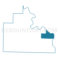
Franklin Voting District, Stone County, Arkansas
About
Outline

Summary
| Unique Area Identifier | 528263 |
| Name | Franklin Voting District |
| County | Stone County |
| State | Arkansas |
| Area (square miles) | 27.64 |
| Land Area (square miles) | 27.10 |
| Water Area (square miles) | 0.54 |
| % of Land Area | 98.04 |
| % of Water Area | 1.96 |
| Latitude of the Internal Point | 35.87456950 |
| Longtitude of the Internal Point | -91.91907070 |
Maps


Graphs
Select a template below for downloading or customizing gragh for Franklin Voting District, Stone County, Arkansas


Neighbors
Neighoring Voting District (by Name) Neighboring Voting District on the Map
- Arbana Voting District, Stone County, AR
- Blue Mountain East Voting District, Stone County, AR
- Cushman-Union Voting District, Independence County, AR
- GUION RURAL Voting District, Izard County, AR
- Jones Voting District, Stone County, AR
- LAFFERTY Voting District, Izard County, AR
- Red Stripe Voting District, Stone County, AR
- Washington Voting District, Stone County, AR
- Washington Voting District, Independence County, AR
Top 10 Neighboring County Subdivision (by Population) Neighboring County Subdivision on the Map
- Blue Mountain township, Stone County, AR (3,639)
- Cushman-Union township, Independence County, AR (1,420)
- Washington township, Independence County, AR (969)
- Arbana township, Stone County, AR (861)
- Franklin township, Stone County, AR (547)
- Red Stripe township, Stone County, AR (340)
- Washington township, Stone County, AR (263)
- Guion township, Izard County, AR (113)
- Lafferty township, Izard County, AR (82)
- Jones township, Stone County, AR (67)
Top 10 Neighboring Unified School District (by Population) Neighboring Unified School District on the Map
- Batesville School District, AR (19,573)
- Mountain View School District, AR (12,192)
- Melbourne School District, AR (5,339)
Top 10 Neighboring State Legislative District Lower Chamber (by Population) Neighboring State Legislative District Lower Chamber on the Map
Top 10 Neighboring State Legislative District Upper Chamber (by Population) Neighboring State Legislative District Upper Chamber on the Map
Top 10 Neighboring 111th Congressional District (by Population) Neighboring 111th Congressional District on the Map
Top 10 Neighboring Census Tract (by Population) Neighboring Census Tract on the Map
- Census Tract 4901, Independence County, AR (6,263)
- Census Tract 9604, Izard County, AR (2,549)
- Census Tract 9502.01, Stone County, AR (1,657)
Top 10 Neighboring 5-Digit ZIP Code Tabulation Area (by Population) Neighboring 5-Digit ZIP Code Tabulation Area on the Map
- 72501, AR (25,099)
- 72560, AR (8,754)
- 72561, AR (981)
- 72567, AR (262)
- 72555, AR (182)
- 72540, AR (149)