


Marcella Voting District, Stone County, Arkansas
About
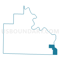
Outline

Summary
| Unique Area Identifier | 528248 |
| Name | Marcella Voting District |
| County | Stone County |
| State | Arkansas |
| Area (square miles) | 16.69 |
| Land Area (square miles) | 16.45 |
| Water Area (square miles) | 0.24 |
| % of Land Area | 98.56 |
| % of Water Area | 1.44 |
| Latitude of the Internal Point | 35.74764520 |
| Longtitude of the Internal Point | -91.86895240 |
Maps


Graphs
Select a template below for downloading or customizing gragh for Marcella Voting District, Stone County, Arkansas


Neighbors
Neighoring Voting District (by Name) Neighboring Voting District on the Map
- Arbana Voting District, Stone County, AR
- Grassey Voting District, Cleburne County, AR
- Greenbrier TWP Voting District, Independence County, AR
- Healing Springs Voting District, Cleburne County, AR
- Red Stripe Voting District, Stone County, AR
- Washington Voting District, Independence County, AR
- Wilson Voting District, Stone County, AR
Top 10 Neighboring County Subdivision (by Population) Neighboring County Subdivision on the Map
- Greenbrier township, Independence County, AR (1,807)
- Grassey township, Cleburne County, AR (1,184)
- Healing Springs township, Cleburne County, AR (975)
- Washington township, Independence County, AR (969)
- Arbana township, Stone County, AR (861)
- Red Stripe township, Stone County, AR (340)
- Marcella township, Stone County, AR (229)
Top 10 Neighboring Unified School District (by Population) Neighboring Unified School District on the Map
- Batesville School District, AR (19,573)
- Mountain View School District, AR (12,192)
- Concord Public Schools, AR (4,463)
Top 10 Neighboring State Legislative District Lower Chamber (by Population) Neighboring State Legislative District Lower Chamber on the Map
- State House District 59, AR (29,163)
- State House District 72, AR (28,138)
- State House District 71, AR (26,638)
Top 10 Neighboring State Legislative District Upper Chamber (by Population) Neighboring State Legislative District Upper Chamber on the Map
Top 10 Neighboring 111th Congressional District (by Population) Neighboring 111th Congressional District on the Map
Top 10 Neighboring Census Tract (by Population) Neighboring Census Tract on the Map
- Census Tract 4907, Independence County, AR (6,879)
- Census Tract 4901, Independence County, AR (6,263)
- Census Tract 4801, Cleburne County, AR (4,298)
- Census Tract 9502.01, Stone County, AR (1,657)
Top 10 Neighboring 5-Digit ZIP Code Tabulation Area (by Population) Neighboring 5-Digit ZIP Code Tabulation Area on the Map
- 72501, AR (25,099)
- 72560, AR (8,754)
- 72530, AR (1,987)
- 72523, AR (1,091)
- 72550, AR (985)
- 72567, AR (262)
- 72555, AR (182)