


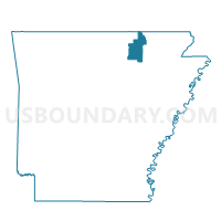
Piney Fork Voting District, Sharp County, Arkansas
About
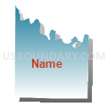
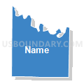
Outline

Summary
| Unique Area Identifier | 528233 |
| Name | Piney Fork Voting District |
| County | Sharp County |
| State | Arkansas |
| Area (square miles) | 35.19 |
| Land Area (square miles) | 35.14 |
| Water Area (square miles) | 0.06 |
| % of Land Area | 99.84 |
| % of Water Area | 0.16 |
| Latitude of the Internal Point | 36.07148550 |
| Longtitude of the Internal Point | -91.62947320 |
Maps


Graphs
Select a template below for downloading or customizing gragh for Piney Fork Voting District, Sharp County, Arkansas


Neighbors
Neighoring Voting District (by Name) Neighboring Voting District on the Map
- BIG SPRING Voting District, Izard County, AR
- East Sullivan Voting District, Sharp County, AR
- JEFFERSON TWP D Voting District, Izard County, AR
- Lave Creek Voting District, Sharp County, AR
- Morgan Voting District, Sharp County, AR
- STRAWBERRY Voting District, Izard County, AR
- Washington Voting District, Sharp County, AR
- West Sullivan Voting District, Sharp County, AR
- ZION Voting District, Izard County, AR
Top 10 Neighboring County Subdivision (by Population) Neighboring County Subdivision on the Map
- Jefferson township, Izard County, AR (2,293)
- Piney Fork township, Sharp County, AR (944)
- West Sullivan township, Sharp County, AR (449)
- Lave Creek township, Sharp County, AR (355)
- Pleasant Hill township, Izard County, AR (349)
- East Sullivan township, Sharp County, AR (321)
- Strawberry township, Izard County, AR (276)
- Big Spring township, Izard County, AR (246)
- Morgan township, Sharp County, AR (233)
- Washington township, Sharp County, AR (221)
Top 10 Neighboring Place (by Population) Neighboring Place on the Map
Top 10 Neighboring Unified School District (by Population) Neighboring Unified School District on the Map
- Highland School District, AR (11,696)
- Cave City School District, AR (8,385)
- Izard Cty Consolidated Schools, AR (4,831)
Top 10 Neighboring State Legislative District Lower Chamber (by Population) Neighboring State Legislative District Lower Chamber on the Map
- State House District 82, AR (28,911)
- State House District 80, AR (27,905)
- State House District 71, AR (26,638)
Top 10 Neighboring State Legislative District Upper Chamber (by Population) Neighboring State Legislative District Upper Chamber on the Map
Top 10 Neighboring 111th Congressional District (by Population) Neighboring 111th Congressional District on the Map
Top 10 Neighboring Census Tract (by Population) Neighboring Census Tract on the Map
- Census Tract 4704, Sharp County, AR (5,999)
- Census Tract 4703, Sharp County, AR (3,917)
- Census Tract 9601, Izard County, AR (3,127)
- Census Tract 9604, Izard County, AR (2,549)