


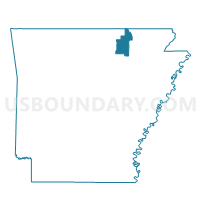
Davidson Voting District, Sharp County, Arkansas
About
Outline

Summary
| Unique Area Identifier | 528230 |
| Name | Davidson Voting District |
| County | Sharp County |
| State | Arkansas |
| Area (square miles) | 22.10 |
| Land Area (square miles) | 22.10 |
| Water Area (square miles) | 0.00 |
| % of Land Area | 100.00 |
| % of Water Area | 0.00 |
| Latitude of the Internal Point | 36.19662000 |
| Longtitude of the Internal Point | -91.49780140 |
Maps


Graphs
Select a template below for downloading or customizing gragh for Davidson Voting District, Sharp County, Arkansas


Neighbors
Neighoring Voting District (by Name) Neighboring Voting District on the Map
- Highland Voting District, Sharp County, AR
- Jackson Voting District, Sharp County, AR
- Morgan Voting District, Sharp County, AR
- North Lebanon Voting District, Sharp County, AR
- Richwoods Voting District, Sharp County, AR
Top 10 Neighboring County Subdivision (by Population) Neighboring County Subdivision on the Map
- Richwoods township, Sharp County, AR (1,827)
- Highland township, Sharp County, AR (1,097)
- Jackson township, Sharp County, AR (295)
- Morgan township, Sharp County, AR (233)
- Davidson township, Sharp County, AR (167)
- North Lebanon township, Sharp County, AR (59)
Top 10 Neighboring Place (by Population) Neighboring Place on the Map
Top 10 Neighboring Unified School District (by Population) Neighboring Unified School District on the Map
- Highland School District, AR (11,696)
- Hillcrest School District, AR (3,680)
- Twin Rivers School District, AR (3,374)