


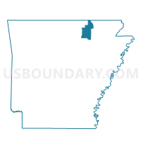
North Union Voting District, Sharp County, Arkansas
About
Outline

Summary
| Unique Area Identifier | 528221 |
| Name | North Union Voting District |
| County | Sharp County |
| State | Arkansas |
| Area (square miles) | 18.88 |
| Land Area (square miles) | 18.88 |
| Water Area (square miles) | 0.00 |
| % of Land Area | 100.00 |
| % of Water Area | 0.00 |
| Latitude of the Internal Point | 36.36937200 |
| Longtitude of the Internal Point | -91.31554260 |
Maps


Graphs
Select a template below for downloading or customizing gragh for North Union Voting District, Sharp County, Arkansas


Neighbors
Neighoring Voting District (by Name) Neighboring Voting District on the Map
- Jane's Creek Voting District, Randolph County, AR
- Lower North Voting District, Sharp County, AR
- Ozark Voting District, Sharp County, AR
- South Union Voting District, Sharp County, AR
- Union Voting District, Randolph County, AR
Top 10 Neighboring County Subdivision (by Population) Neighboring County Subdivision on the Map
- Janes Creek township, Randolph County, AR (702)
- Ozark township, Sharp County, AR (672)
- Lower North township, Sharp County, AR (497)
- South Union township, Sharp County, AR (334)
- North Union township, Sharp County, AR (160)
- Union township, Randolph County, AR (111)