


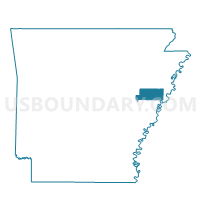
BLACKFISH PCT 7, St. Francis County, Arkansas
About
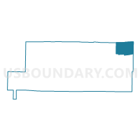
Outline

Summary
| Unique Area Identifier | 527978 |
| Name | BLACKFISH PCT 7 |
| County | St. Francis County |
| State | Arkansas |
| Area (square miles) | 23.95 |
| Land Area (square miles) | 23.62 |
| Water Area (square miles) | 0.33 |
| % of Land Area | 98.62 |
| % of Water Area | 1.38 |
| Latitude of the Internal Point | 35.11314880 |
| Longtitude of the Internal Point | -90.44980470 |
Maps

Graphs
Select a template below for downloading or customizing gragh for BLACKFISH PCT 7, St. Francis County, Arkansas


Neighbors
Neighoring Voting District (by Name) Neighboring Voting District on the Map
- BLACKFISH PCT 7, St. Francis County, AR
- Bob Ward, Crittenden County, AR
- HETH PCT 6, St. Francis County, AR
- Jackson 1 Voting District, Crittenden County, AR
- Jennette Voting District, Crittenden County, AR
- ROUND POUND PCT 12, St. Francis County, AR
- South Tyronza Voting District, Crittenden County, AR
- Tyronza Voting District, Cross County, AR
Top 10 Neighboring County Subdivision (by Population) Neighboring County Subdivision on the Map
- Tyronza township, Crittenden County, AR (3,088)
- Jackson township, Crittenden County, AR (1,352)
- Tyronza township, Cross County, AR (1,323)
- Bob Ward township, Crittenden County, AR (982)
- Griggs township, St. Francis County, AR (746)
- Heth township, St. Francis County, AR (576)
Top 10 Neighboring Place (by Population) Neighboring Place on the Map
Top 10 Neighboring Unified School District (by Population) Neighboring Unified School District on the Map
- West Memphis School District, AR (25,528)
- Forrest City School District, AR (23,630)
- Wynne Public Schools, AR (14,318)
- Earle School District, AR (3,179)
- Hughes School District, AR (3,154)
Top 10 Neighboring State Legislative District Lower Chamber (by Population) Neighboring State Legislative District Lower Chamber on the Map
- State House District 57, AR (24,379)
- State House District 52, AR (24,057)
- State House District 54, AR (21,956)
Top 10 Neighboring State Legislative District Upper Chamber (by Population) Neighboring State Legislative District Upper Chamber on the Map
Top 10 Neighboring 111th Congressional District (by Population) Neighboring 111th Congressional District on the Map
Top 10 Neighboring Census Tract (by Population) Neighboring Census Tract on the Map
- Census Tract 306, Crittenden County, AR (4,875)
- Census Tract 9601, St. Francis County, AR (3,136)
- Census Tract 9501, Cross County, AR (1,454)
- Census Tract 310, Crittenden County, AR (1,406)