


Union Voting District, Prairie County, Arkansas
About
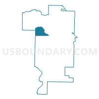
Outline

Summary
| Unique Area Identifier | 527773 |
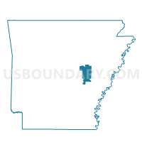
| Name | Union Voting District |
| County | Prairie County |
| State | Arkansas |
| Area (square miles) | 17.63 |
| Land Area (square miles) | 17.36 |
| Water Area (square miles) | 0.28 |
| % of Land Area | 98.43 |
| % of Water Area | 1.57 |
| Latitude of the Internal Point | 34.91037820 |
| Longtitude of the Internal Point | -91.64579840 |
Maps

Graphs
Select a template below for downloading or customizing gragh for Union Voting District, Prairie County, Arkansas


Neighbors
Neighoring Voting District (by Name) Neighboring Voting District on the Map
- Bullard Voting District, Prairie County, AR
- Center Voting District, Prairie County, AR
- Hazen TWP Voting District, Prairie County, AR
- Hickory Plain Voting District, Prairie County, AR
- TOTTEN Voting District, Lonoke County, AR
- White River Voting District, Prairie County, AR
Top 10 Neighboring County Subdivision (by Population) Neighboring County Subdivision on the Map
- White River township, Prairie County, AR (2,247)
- Hazen township, Prairie County, AR (1,772)
- Hickory Plain township, Prairie County, AR (616)
- Center township, Prairie County, AR (474)
- Totten township, Lonoke County, AR (423)
- Bullard township, Prairie County, AR (172)
- Union township, Prairie County, AR (147)
Top 10 Neighboring Unified School District (by Population) Neighboring Unified School District on the Map
- Carlisle School District, AR (4,202)
- Des Arc Public Schools, AR (3,596)
- Hazen School District, AR (2,732)
Top 10 Neighboring State Legislative District Lower Chamber (by Population) Neighboring State Legislative District Lower Chamber on the Map
Top 10 Neighboring State Legislative District Upper Chamber (by Population) Neighboring State Legislative District Upper Chamber on the Map
Top 10 Neighboring 111th Congressional District (by Population) Neighboring 111th Congressional District on the Map
Top 10 Neighboring Census Tract (by Population) Neighboring Census Tract on the Map
- Census Tract 201.04, Lonoke County, AR (7,068)
- Census Tract 4601, Prairie County, AR (3,763)
- Census Tract 204, Lonoke County, AR (3,095)
- Census Tract 4602, Prairie County, AR (2,681)